Green Meadows, Oregon | |
|---|---|
 Green Meadows  Green Meadows | |
| Coordinates: 45°36′59″N 118°48′10″W / 45.61639°N 118.80278°W | |
| Country | United States |
| State | Oregon |
| County | Umatilla |
| Area | |
| • Total | 1.23 sq mi (3.18 km2) |
| • Land | 1.23 sq mi (3.18 km2) |
| • Water | 0.00 sq mi (0.00 km2) |
| Elevation | 1,161 ft (354 m) |
| Population | |
| • Total | 675 |
| • Density | 550.57/sq mi (212.59/km2) |
| Time zone | UTC-8 (Pacific (PST)) |
| • Summer (DST) | UTC-7 (PDT) |
| ZIP Code | 97801 (Pendleton) |
| Area code(s) | 541/458 |
| FIPS code | 41-31115 |
| GNIS feature ID | 2611733[2] |
Green Meadows is an unincorporated community and census-designated place (CDP) in Umatilla County, Oregon, United States. It was first listed as a CDP following the 2010 census.[2]
The CDP is in central Umatilla County along U.S. Route 395, 5 miles (8 km) south of Pendleton, the county seat. It is on the east side of the valley of McKay Creek, a north-flowing tributary of the Umatilla River, which in turn is a west-flowing tributary of the Columbia.
Demographics
| Census | Pop. | Note | %± |
|---|---|---|---|
| 2020 | 675 | — | |
| U.S. Decennial Census[4][3] | |||
References
- ↑ "ArcGIS REST Services Directory". United States Census Bureau. Retrieved October 12, 2022.
- 1 2 3 U.S. Geological Survey Geographic Names Information System: Green Meadows, Oregon
- 1 2 "Census Population API". United States Census Bureau. Retrieved October 12, 2022.
- ↑ "Census of Population and Housing". Census.gov. Retrieved June 4, 2016.
Municipalities and communities of Umatilla County, Oregon, United States | ||
|---|---|---|
| Cities | 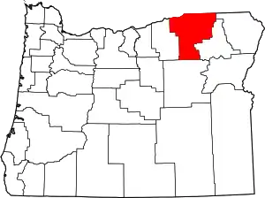 Umatilla County map | |
| CDPs | ||
| Other communities | ||
| Indian reservation | ||
| Ghost towns | ||
This article is issued from Wikipedia. The text is licensed under Creative Commons - Attribution - Sharealike. Additional terms may apply for the media files.