Guichón | |
|---|---|
City | |
 Guichón Location in Uruguay | |
| Coordinates: 32°21′0″S 57°12′0″W / 32.35000°S 57.20000°W | |
| Country | |
| Department | |
| Population (2011 Census) | |
| • Total | 5,039 |
| Time zone | UTC -3 |
| Postal code | 60008 |
| Dial plan | +598 4742 (+4 digits) |
Guichón is a small city in the Paysandú Department of western Uruguay.
Geography
It is located on Route 90, 17 kilometres (11 mi) west of its intersection with Route 4 and 19 kilometres (12 mi) east of its intersection with Route 25.
History
On 15 June 1907, it was declared "Pueblo" (village) by the Act of Ley Nº 3.203.[1] Until then it had been the head of the judicial section "Palmar". On 22 June 1955, its status was elevated to "Villa" (town) by the Act of Ley Nº 12.199,[2] and then on 17 November 1964, to "Ciudad" (city) by the Act of Ley Nº 13.299.[3]
Population
In 2011 Guichón had a population of 5,039.[4]
| Year | Population |
|---|---|
| 1908 | 2,444 |
| 1963 | 3,683 |
| 1975 | 4,726 |
| 1985 | 4,284 |
| 1996 | 4,826 |
| 2004 | 5,025 |
| 2011 | 5,039 |
Source: Instituto Nacional de Estadística de Uruguay[1]
Places of worship
- Mary Help of Christians Parish Church (Roman Catholic)
References
- 1 2 "Statistics of urban localities (1908–2004)" (PDF). INE. 2012. Archived from the original (PDF) on 13 November 2009. Retrieved 4 September 2012.
- ↑ "Ley Nº 12.199". República Oriental del Uruguay, Poder Legislativo. 1955. Archived from the original on 4 March 2016. Retrieved 4 September 2012.
- ↑ "LEY N° 13.299". República Oriental del Uruguay, Poder Legislativo. 1964. Archived from the original on 6 October 2014. Retrieved 4 September 2012.
- ↑ "Censos 2011 Cuadros Paysandú". INE. 2012. Retrieved 25 August 2012.
External links
Capital: Paysandú | ||
| Municipalities | 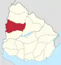 | |
| Towns and villages | ||
| Sights | ||
This article is issued from Wikipedia. The text is licensed under Creative Commons - Attribution - Sharealike. Additional terms may apply for the media files.