Hæåk | |
|---|---|
Village | |
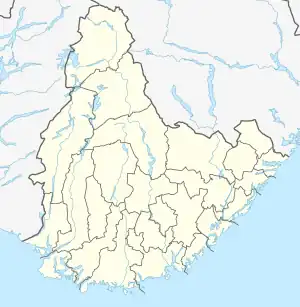 Hæåk Location of the village  Hæåk Hæåk (Norway) | |
| Coordinates: 58°10′42″N 06°59′23″E / 58.17833°N 6.98972°E | |
| Country | Norway |
| Region | Southern Norway |
| County | Agder |
| District | Lister |
| Municipality | Lyngdal |
| Elevation | 278 m (912 ft) |
| Time zone | UTC+01:00 (CET) |
| • Summer (DST) | UTC+02:00 (CEST) |
| Post Code | 8680 Trofors |
Hæåk is a very small farming village in Lyngdal municipality in Agder county, Norway. The village is located about 8 kilometres (5.0 mi) northwest of the town of Lyngdal. Originally, the farm was not accessible by road, and only a few farmers lived there. However, in 1987 a steep road leading down to Hæåk was built, and it has since become a popular place for bicycling enthusiasts.
The main industry in the area of Hæåk is gravel production.
References
- ↑ "Hæåk, Lyngdal (Vest-Agder)". yr.no. Retrieved 16 October 2016.
This article is issued from Wikipedia. The text is licensed under Creative Commons - Attribution - Sharealike. Additional terms may apply for the media files.