Hallworthy
| |
|---|---|
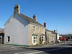 Cottages at Hallworthy | |
 Hallworthy Location within Cornwall | |
| OS grid reference | SX180878 |
| Civil parish | |
| Unitary authority | |
| Ceremonial county | |
| Region | |
| Country | England |
| Sovereign state | United Kingdom |
| Post town | Camelford |
| Postcode district | PL32 |
Hallworthy (Cornish: Halworgi[1]) is a hamlet in the parish of Treneglos, Cornwall, England. It is at a crossroads on the A395 road from Davidstow to Launceston.[2] To the east is a plantation called Wilsey Down Forest.[3] It is in the civil parish of Davidstow
References
- ↑ "Cornish Language Partnership : Place names in the SWF". Magakernow.org.uk. Archived from the original on 15 May 2013. Retrieved 17 September 2012.
- ↑ Ordnance Survey: Landranger map sheet 190 Bude & Clovelly (Map). Ordnance Survey. ISBN 978-0-319-23145-6.
- ↑ Ordnance Survey One-inch Map of Great Britain; Bodmin and Launceston, sheet 186. 1961.
| Unitary authorities | |
|---|---|
| Major settlements (cities in italics) |
|
| Rivers | |
| Topics | |
This article is issued from Wikipedia. The text is licensed under Creative Commons - Attribution - Sharealike. Additional terms may apply for the media files.