Hammarland | |
|---|---|
Municipality | |
| Hammarlands kommun | |
   _2.jpg.webp) | |
 Coat of arms | |
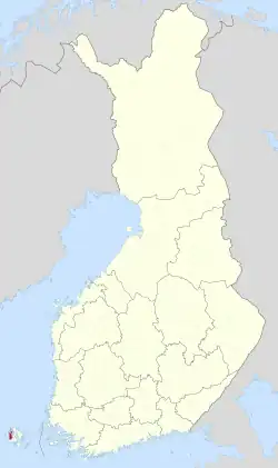 Location of Hammarland in Finland | |
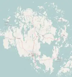 Hammarland Location in Åland | |
| Coordinates: 60°13′N 019°44′E / 60.217°N 19.733°E | |
| Country | |
| Region | Åland |
| Sub-region | Åland Countryside sub-region |
| Government | |
| • Municipal manager | Kurt Carlsson |
| Area (2018-01-01)[1] | |
| • Total | 1,224.17 km2 (472.65 sq mi) |
| • Land | 138.55 km2 (53.49 sq mi) |
| • Water | 1,084.84 km2 (418.86 sq mi) |
| • Rank | 285th largest in Finland |
| Population (2023-09-30)[2] | |
| • Total | 1,659 |
| • Rank | 275th largest in Finland |
| • Density | 11.97/km2 (31.0/sq mi) |
| Population by native language | |
| • Swedish | 89.1% (official) |
| • Finnish | 3.6% |
| • Others | 7.2% |
| Population by age | |
| • 0 to 14 | 17.7% |
| • 15 to 64 | 60.2% |
| • 65 or older | 22.1% |
| Time zone | UTC+02:00 (EET) |
| • Summer (DST) | UTC+03:00 (EEST) |
| Website | www.hammarland.ax |
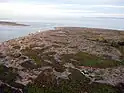
Hammarland is a municipality of Åland, an autonomous territory of Finland.
The municipality has a population of 1,659 (30 September 2023)[2] and covers an area of 1,224.17 square kilometres (472.65 sq mi) of which 1,084.84 km2 (418.86 sq mi) is water.[1] The population density is 11.97 inhabitants per square kilometre (31.0/sq mi).
The municipality is unilingually Swedish. 89% of its population has Swedish as their native language,[3] making Hammarland one of the municipalities with the highest percentage of Swedish-speakers in Finland.
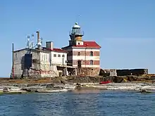
Märket, the westernmost point of Finland, is an exclave of Hammarland.[5]
The most significant main road of Hammarland is the Highway 1 between Mariehamn and Eckerö.
References
- 1 2 "Area of Finnish Municipalities 1.1.2018" (PDF). National Land Survey of Finland. Retrieved 30 January 2018.
- 1 2 "Preliminary population statistics 2023, September". StatFin. Statistics Finland. Retrieved 26 October 2023.
- 1 2 "Demographic Structure by area as of 31 December 2022". Statistics Finland's PX-Web databases. Statistics Finland. Retrieved 6 September 2023.
- ↑ "Population according to age (1-year) and sex by area and the regional division of each statistical reference year, 2003–2020". StatFin. Statistics Finland. Retrieved 2 May 2021.
- ↑ Citizen's Map Site – National Land Survey of Finland
External links
![]() Media related to Hammarland at Wikimedia Commons
Media related to Hammarland at Wikimedia Commons
- Municipal of Hammarland – Official website The official website of Hammarland]
Places adjacent to Hammarland | ||||||||||||||||
|---|---|---|---|---|---|---|---|---|---|---|---|---|---|---|---|---|
| ||||||||||||||||