Hartland, Michigan | |
|---|---|
.jpg.webp) Looking south along Hartland Road | |
 Hartland  Hartland | |
| Coordinates: 42°39′24″N 83°45′15″W / 42.65667°N 83.75417°W | |
| Country | United States |
| State | Michigan |
| County | Livingston |
| Township | Hartland |
| Area | |
| • Total | 2.28 sq mi (5.92 km2) |
| • Land | 2.28 sq mi (5.91 km2) |
| • Water | 0.00 sq mi (0.00 km2) |
| Elevation | 949 ft (289 m) |
| Population (2020) | |
| • Total | 777 |
| • Density | 340.34/sq mi (131.43/km2) |
| Time zone | UTC-5 (Eastern (EST)) |
| • Summer (DST) | UTC-4 (EDT) |
| ZIP Code | 48353 |
| Area code | 810 |
| FIPS code | 26-37020 |
| GNIS feature ID | 2804670[2] |
Hartland is a census-designated place (CDP) comprising the main community in Hartland Township, in Livingston County, Michigan, United States. US Highway 23 forms the western edge of the community; the highway leads north 27 miles (43 km) to Flint and south the same distance to Ann Arbor.
Hartland was first listed as a CDP prior to the 2020 census.[2]
Demographics
| Census | Pop. | Note | %± |
|---|---|---|---|
| 2020 | 777 | — | |
| U.S. Decennial Census[3] | |||
References
- ↑ "2020 U.S. Gazetteer Files". United States Census Bureau. Retrieved May 21, 2022.
- 1 2 3 "Hartland Census Designated Place". Geographic Names Information System. United States Geological Survey, United States Department of the Interior.
- ↑ "Census of Population and Housing". Census.gov. Retrieved June 4, 2016.
Municipalities and communities of Livingston County, Michigan, United States | ||
|---|---|---|
| Cities | 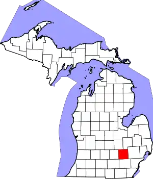 Map of Michigan highlighting Livingston County | |
| Villages | ||
| Charter townships | ||
| Civil townships | ||
| CDPs | ||
| Other communities |
| |
| Footnotes | ‡This populated place also has portions in an adjacent county or counties | |
This article is issued from Wikipedia. The text is licensed under Creative Commons - Attribution - Sharealike. Additional terms may apply for the media files.