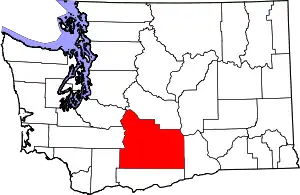
Harwood, Washington | |
|---|---|
 Harwood, Washington Location of Harwood, Washington | |
| Coordinates: 46°34′56″N 120°39′22″W / 46.5823477°N 120.6561801°W[1] | |
| Country | United States |
| State | Washington |
| County | Yakima |
| Elevation | 1,276 ft (389 m) |
| Time zone | UTC-8 (Pacific (PST)) |
| • Summer (DST) | UTC-7 (PDT) |
| ZIP code | 98908 |
| Area code | 509 |
| GNIS feature ID | 1512280[2] |
Harwood is an unincorporated community in Yakima County, Washington, United States, located immediately west of Yakima.
References
- ↑ "Harwood". Geographic Names Information System. United States Geological Survey, United States Department of the Interior. Retrieved October 27, 2012.
- 1 2 "US Board on Geographic Names". United States Geological Survey. October 25, 2007. Retrieved January 31, 2008.
This article is issued from Wikipedia. The text is licensed under Creative Commons - Attribution - Sharealike. Additional terms may apply for the media files.
