Heinsdorfergrund | |
|---|---|
 Coat of arms | |
Location of Heinsdorfergrund within Vogtlandkreis district 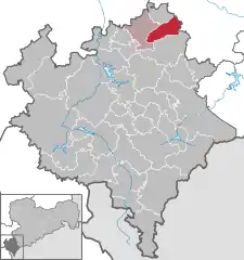 | |
 Heinsdorfergrund  Heinsdorfergrund | |
| Coordinates: 50°37′20″N 12°22′20″E / 50.62222°N 12.37222°E | |
| Country | Germany |
| State | Saxony |
| District | Vogtlandkreis |
| Subdivisions | 3 |
| Area | |
| • Total | 21.86 km2 (8.44 sq mi) |
| Elevation | 380 m (1,250 ft) |
| Population (2021-12-31)[1] | |
| • Total | 1,931 |
| • Density | 88/km2 (230/sq mi) |
| Time zone | UTC+01:00 (CET) |
| • Summer (DST) | UTC+02:00 (CEST) |
| Postal codes | 08468 |
| Dialling codes | 03765,037600 |
| Vehicle registration | V, AE, OVL, PL, RC |
| Website | www.heinsdorfergrund-vogtland.de |
Heinsdorfergrund (German pronunciation: [ˈhaɪ̯nsdɔʁfɐˌɡʁʊnt] ⓘ) is a municipality in the Vogtlandkreis district, in Saxony, Germany. The municipality was first mentioned in 1323 as Heinrichesdorf.
References
This article is issued from Wikipedia. The text is licensed under Creative Commons - Attribution - Sharealike. Additional terms may apply for the media files.