Henryville | |
|---|---|
 | |
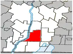 Location within Le Haut-Richelieu RCM. | |
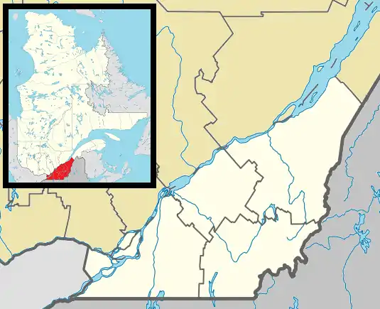 Henryville Location in southern Quebec. | |
| Coordinates: 45°08′N 73°11′W / 45.133°N 73.183°W[1] | |
| Country | |
| Province | |
| Region | Montérégie |
| RCM | Le Haut-Richelieu |
| Constituted | December 15, 1999 |
| Government | |
| • Mayor | Serges Lafrance |
| • Federal riding | Brome—Missisquoi |
| • Prov. riding | Iberville |
| Area | |
| • Total | 69.60 km2 (26.87 sq mi) |
| • Land | 64.82 km2 (25.03 sq mi) |
| Population (2021)[4] | |
| • Total | 1,497 |
| • Density | 23.1/km2 (60/sq mi) |
| • Pop 2016-2021 | |
| • Dwellings | 702 |
| Time zone | UTC−5 (EST) |
| • Summer (DST) | UTC−4 (EDT) |
| Postal code(s) | |
| Area code(s) | 450 and 579 |
| Highways | |
| Website | www.municipalite- henryville.com |
Henryville (French pronunciation: [ɑ̃ʁivil]) is a municipality in Le Haut-Richelieu Regional County Municipality in the Montérégie region of Quebec, Canada. The population as of the Canada 2021 Census was 1,497. Henryville is the birthplace of Bat Masterson, a figure from the late 19th century U.S. wild west who became a New York City newspaper columnist during the early 20th century.
Demographics
Population
Canada census – Henryville community profile
| 2021 | 2016 | 2011 | |
|---|---|---|---|
| Population | 1,497 (+6.5% from 2016) | 1,406 (-4.0% from 2011) | 1,464 (-4.3% from 2006) |
| Land area | 64.82 km2 (25.03 sq mi) | 65.41 km2 (25.25 sq mi) | 64.92 km2 (25.07 sq mi) |
| Population density | 23.1/km2 (60/sq mi) | 21.5/km2 (56/sq mi) | 22.6/km2 (59/sq mi) |
| Median age | 42.8 (M: 42.4, F: 44.4) | 46.1 (M: 45.3, F: 47.6) | 46.9 (M: 47.0, F: 46.8) |
| Private dwellings | 702 (total) 612 (occupied) | 697 (total) | 719 (total) |
| Median household income | $70,500 | $57,259 | $49,876 |
|
|
|
Language
| Canada Census Mother Tongue - Henryville, Quebec[9] | ||||||||||||||||||
|---|---|---|---|---|---|---|---|---|---|---|---|---|---|---|---|---|---|---|
| Census | Total | French |
English |
French & English |
Other | |||||||||||||
| Year | Responses | Count | Trend | Pop % | Count | Trend | Pop % | Count | Trend | Pop % | Count | Trend | Pop % | |||||
2021 |
1,475 |
1,345 | 91.2% | 55 | 3.7% | 25 | 1.7% | 45 | 3.1% | |||||||||
2016 |
1,410 |
1,295 | 91.8% | 60 | 4.3% | 10 | 0.7% | 35 | 2.5% | |||||||||
2011 |
1,440 |
1,300 | 90.3% | 85 | 5.9% | 15 | 1.0% | 40 | 2.8% | |||||||||
2006 |
1,475 |
1,320 | 89.5% | 95 | 6.4% | 20 | 1.4% | 40 | 2.7% | |||||||||
2001 |
1,445 |
1,280 | 88.6% | 95 | 6.6% | 30 | 2.1% | 40 | 2.8% | |||||||||
1996 |
840 |
730 | n/a | 86.9% | 25 | n/a | 3.0% | 10 | n/a | 1.2% | 75 | n/a | 8.9% | |||||
See also
References
- ↑ "Banque de noms de lieux du Québec: Reference number 28524". toponymie.gouv.qc.ca (in French). Commission de toponymie du Québec.
- 1 2 Ministère des Affaires municipales, des Régions et de l'Occupation du territoire: Henryville
- ↑ "Parliament of Canada Federal Riding History: BROME--MISSISQUOI (Quebec)". Archived from the original on 2009-06-09. Retrieved 2009-04-20.
- 1 2 3 "2021 Community Profiles". 2021 Canadian Census. Statistics Canada. February 4, 2022. Retrieved 2023-10-19.
- ↑ "2016 Community Profiles". 2016 Canadian Census. Statistics Canada. August 12, 2021. Retrieved 2023-04-06.
- ↑ "2011 Community Profiles". 2011 Canadian Census. Statistics Canada. March 21, 2019. Retrieved 2014-03-09.
- ↑ "2006 Community Profiles". 2006 Canadian Census. Statistics Canada. August 20, 2019.
- ↑ "2001 Community Profiles". 2001 Canadian Census. Statistics Canada. July 18, 2021.
- 1 2 Statistics Canada: 1996, 2001, 2006, 2011, 2016, 2021 census
Adjacent Municipal Subdivisions | |
|---|---|
| Cities & Towns | |
|---|---|
| Municipalities | |
| Parishes | |
| |
This article is issued from Wikipedia. The text is licensed under Creative Commons - Attribution - Sharealike. Additional terms may apply for the media files.