Herink | |
|---|---|
 Common in Herink | |
 Flag  Coat of arms | |
 Herink Location in the Czech Republic | |
| Coordinates: 49°58′0″N 14°34′30″E / 49.96667°N 14.57500°E | |
| Country | |
| Region | Central Bohemian |
| District | Prague-East |
| First mentioned | 1422 |
| Area | |
| • Total | 2.74 km2 (1.06 sq mi) |
| Elevation | 362 m (1,188 ft) |
| Population (2023-01-01)[1] | |
| • Total | 1,046 |
| • Density | 380/km2 (990/sq mi) |
| Time zone | UTC+1 (CET) |
| • Summer (DST) | UTC+2 (CEST) |
| Postal code | 251 70 |
| Website | www |
Herink is a municipality and village in Prague-East District in the Central Bohemian Region of the Czech Republic. It has about 1,000 inhabitants. As of census 2001, Herink had 72 inhabitants[2] and therefore it is one of the fastest-growing municipalities in the country.
Demographics
As of the 2021 census, the population is 1,106, up 165% from 417 in 2011.
| Year | Pop. | ±% |
|---|---|---|
| 1869 | 166 | — |
| 1880 | 162 | −2.4% |
| 1890 | 161 | −0.6% |
| 1900 | 175 | +8.7% |
| 1910 | 154 | −12.0% |
| 1921 | 164 | +6.5% |
| 1930 | 167 | +1.8% |
| 1950 | 109 | −34.7% |
| 1961 | 111 | +1.8% |
| 1970 | 93 | −16.2% |
| 1980 | 88 | −5.4% |
| 1991 | 75 | −14.8% |
| 2001 | 72 | −4.0% |
| 2011 | 417 | +479.2% |
| 2021 | 1,106 | +165.2% |
| Source: Censuses[3][4] | ||
Gallery
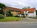 Old farmstead
 Protected linden tree
References
- ↑ "Population of Municipalities – 1 January 2023". Czech Statistical Office. 2023-05-23.
- ↑ "Sčítaní lidu, domů a bytů 2001: Herink" (in Czech). Czech Statistical Office. 2005.
- ↑ "Historický lexikon obcí České republiky 1869–2011 – Okres Praha-východ" (in Czech). Czech Statistical Office. 2015-12-21. pp. 1–2.
- ↑ "Population Census 2021: Population by sex". Public Database. Czech Statistical Office. 2021-03-27.
Wikimedia Commons has media related to Herink.
This article is issued from Wikipedia. The text is licensed under Creative Commons - Attribution - Sharealike. Additional terms may apply for the media files.