Hlavňovice | |
|---|---|
 Centre of Hlavňovice | |
 Hlavňovice Location in the Czech Republic | |
| Coordinates: 49°14′17″N 13°23′42″E / 49.23806°N 13.39500°E | |
| Country | |
| Region | Plzeň |
| District | Klatovy |
| First mentioned | 1428 |
| Area | |
| • Total | 24.10 km2 (9.31 sq mi) |
| Elevation | 687 m (2,254 ft) |
| Population (2023-01-01)[1] | |
| • Total | 500 |
| • Density | 21/km2 (54/sq mi) |
| Time zone | UTC+1 (CET) |
| • Summer (DST) | UTC+2 (CEST) |
| Postal codes | 341 42, 342 01 |
| Website | www |
Hlavňovice is a municipality and village in Klatovy District in the Plzeň Region of the Czech Republic. It has about 500 inhabitants.
Hlavňovice lies approximately 20 kilometres (12 mi) south-east of Klatovy, 58 km (36 mi) south of Plzeň, and 121 km (75 mi) south-west of Prague.
Administrative parts
Villages and hamlets of Častonice, Čeletice, Cihelna, Horní Staňkov, Javoříčko, Libětice, Milínov, Pích, Přestanice, Puchverk, Radostice, Suchá, Zámyšl and Zvíkov are administrative parts of Hlavňovice.
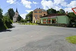
Gallery
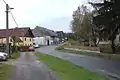 Road
Road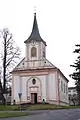 Church of Saint John of Nepomuk
 House in Hlavňovice
References
Wikimedia Commons has media related to Hlavňovice.
This article is issued from Wikipedia. The text is licensed under Creative Commons - Attribution - Sharealike. Additional terms may apply for the media files.