Hobson, Alabama | |
|---|---|
 Hobson, Alabama | |
| Coordinates: 31°28′21″N 88°09′12″W / 31.47250°N 88.15333°W | |
| Country | United States |
| State | Alabama |
| County | Washington |
| Area | |
| • Total | 2.97 sq mi (7.70 km2) |
| • Land | 2.94 sq mi (7.63 km2) |
| • Water | 0.03 sq mi (0.08 km2) |
| Elevation | 148 ft (45 m) |
| Population (2020) | |
| • Total | 100 |
| • Density | 33.97/sq mi (13.11/km2) |
| Time zone | UTC-6 (Central (CST)) |
| • Summer (DST) | UTC-5 (CDT) |
| Area code | 251 |
| GNIS feature ID | 138923[2] |
Hobson is a census-designated place and unincorporated community in Washington County, Alabama, United States. Its population was 126 as of the 2010 census.[3]
Demographics
| Census | Pop. | Note | %± |
|---|---|---|---|
| 2020 | 100 | — | |
| U.S. Decennial Census[4] | |||
References
- ↑ "2020 U.S. Gazetteer Files". United States Census Bureau. Retrieved October 29, 2021.
- ↑ "Hobson". Geographic Names Information System. United States Geological Survey, United States Department of the Interior.
- ↑ "U.S. Census website". United States Census Bureau. Retrieved May 14, 2011.
- ↑ "Census of Population and Housing". Census.gov. Retrieved June 4, 2016.
Municipalities and communities of Washington County, Alabama, United States | ||
|---|---|---|
| Towns | 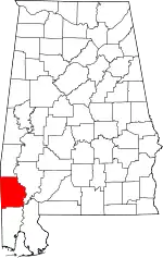 Map of Alabama highlighting Washington County | |
| CDPs | ||
| Unincorporated communities | ||
| Ghost towns | ||
| Indian reservation | ||
| Footnotes | ‡This populated place also has portions in an adjacent county or counties | |
This article is issued from Wikipedia. The text is licensed under Creative Commons - Attribution - Sharealike. Additional terms may apply for the media files.