Hogeland, Montana | |
|---|---|
 Hogeland, Montana  Hogeland, Montana | |
| Coordinates: 48°51′09″N 108°39′32″W / 48.85250°N 108.65889°W | |
| Country | United States |
| State | Montana |
| County | Blaine |
| Area | |
| • Total | 0.51 sq mi (1.32 km2) |
| • Land | 0.51 sq mi (1.32 km2) |
| • Water | 0.00 sq mi (0.00 km2) |
| Elevation | 3,140 ft (960 m) |
| Population (2020) | |
| • Total | 14 |
| • Density | 27.50/sq mi (10.61/km2) |
| Time zone | UTC-7 (Mountain (MST)) |
| • Summer (DST) | UTC-6 (MDT) |
| ZIP code | 59529 |
| Area code | 406 |
| GNIS feature ID | 772456[2] |
Hogeland is an unincorporated rural village in Blaine County, Montana, United States. Hogeland is 23 miles (37 km) north-northeast of Harlem. Hogeland has a post office with ZIP code 59529.[3]
History
The town began as a station stop for the Great Northern Railway in about 1928. It was named for A. H. Hogeland, the chief engineer.[4]
Climate
According to the Köppen Climate Classification system, Hogeland has a semi-arid climate, abbreviated "BSk" on climate maps.[5]
References
- ↑ "ArcGIS REST Services Directory". United States Census Bureau. Retrieved September 5, 2022.
- ↑ "Hogeland". Geographic Names Information System. United States Geological Survey, United States Department of the Interior.
- ↑ United States Postal Service (2012). "USPS - Look Up a ZIP Code". Retrieved February 15, 2012.
- ↑ "Hogeland". Montana Place Names Companion. Montana Historical Society. Retrieved April 5, 2021.
- ↑ Climate Summary for Hogeland, Montana
Municipalities and communities of Blaine County, Montana, United States | ||
|---|---|---|
| Cities | 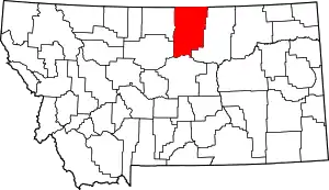 Blaine County map | |
| CDPs | ||
| Other community | ||
| Indian reservations | ||
| Footnotes | ‡This populated place also has portions in an adjacent county or counties | |
This article is issued from Wikipedia. The text is licensed under Creative Commons - Attribution - Sharealike. Additional terms may apply for the media files.