Hokédhe Kué 196E
Myers Lake[1] | |
|---|---|
| Hokédhe Kué Indian Reserve No. 196E | |
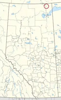 Location in Alberta | |
| First Nation | Smith's Landing |
| Treaty | 8 |
| Country | Canada |
| Province | Alberta |
| Specialized municipality | Wood Buffalo |
| Area | |
| • Total | 440.4 ha (1,088.3 acres) |
Hokédhe Kué 196E, also known as Myers Lake, is an Indian reserve of the Smith's Landing First Nation in Alberta, located within the Regional Municipality of Wood Buffalo.[3][2]
References
- ↑ "Reserve Sites.docx". Retrieved August 13, 2019.
- 1 2 "Reserve/Settlement/Village Detail". Crown–Indigenous Relations and Northern Affairs Canada. Government of Canada. Retrieved August 12, 2019.
- ↑ Government of Alberta (May 25, 2019). Municipal Boundaries (Map). AltaLIS.
| Ethnolinguistic groups (by language family) | |||||||||||||||||||||||||||||
|---|---|---|---|---|---|---|---|---|---|---|---|---|---|---|---|---|---|---|---|---|---|---|---|---|---|---|---|---|---|
| Historical polities | |||||||||||||||||||||||||||||
| Numbered Treaties | |||||||||||||||||||||||||||||
| Tribal councils and band governments |
| ||||||||||||||||||||||||||||

.svg.png.webp)

59°40′53″N 111°17′39″W / 59.6814°N 111.2942°W
This article is issued from Wikipedia. The text is licensed under Creative Commons - Attribution - Sharealike. Additional terms may apply for the media files.