Hpakant Township
ဖားကန့်မြို့နယ် | |
|---|---|
 | |
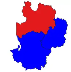 Location in Mohnyin district | |
| Country | |
| State | Kachin State |
| District | Mohnyin District |
| Time zone | UTC+6:30 (MST) |
Hpakant Township[1] (Burmese: ဖားကန့်မြို့နယ်; also Kamaing Township) is a township of Mohnyin District in the Kachin State of Burma (Myanmar).[2] The administrative centre is Hpakant. The major town is Kamaing.
See also
External links
- "Kamaing Google Satellite Map" map of the administrative area with a listing of principal settlements (from Maplandia)
References
- ↑ "Myanmar States/Divisions & Townships Overview Map" Archived 2010-12-03 at the Wayback Machine Myanmar Information Management Unit (MIMU)
- ↑ "Developing Kachin State with peace, unity and pleasantness" Archived 2011-07-19 at the Wayback Machine MRTV3
25°37′N 96°19′E / 25.617°N 96.317°E
Capital: Myitkyina | ||
| Bhamo District |   | |
| Mohnyin District | ||
| Myitkyina District | ||
| Putao District | ||
| Main cities and towns | ||
This article is issued from Wikipedia. The text is licensed under Creative Commons - Attribution - Sharealike. Additional terms may apply for the media files.