Ingrandes | |
|---|---|
Part of Ingrandes-Le Fresne sur Loire | |
 | |
.svg.png.webp) Coat of arms | |
Location of Ingrandes | |
 Ingrandes  Ingrandes | |
| Coordinates: 47°24′11″N 0°55′20″W / 47.4031°N 0.9222°W | |
| Country | France |
| Region | Pays de la Loire |
| Department | Maine-et-Loire |
| Arrondissement | Angers |
| Canton | Chalonnes-sur-Loire |
| Commune | Ingrandes-Le Fresne sur Loire |
| Area 1 | 6.65 km2 (2.57 sq mi) |
| Population (2013)[1] | 1,661 |
| • Density | 250/km2 (650/sq mi) |
| Demonym(s) | Ingrandais, Ingrandaise |
| Time zone | UTC+01:00 (CET) |
| • Summer (DST) | UTC+02:00 (CEST) |
| Postal code | 49123 |
| Elevation | 7–69 m (23–226 ft) |
| 1 French Land Register data, which excludes lakes, ponds, glaciers > 1 km2 (0.386 sq mi or 247 acres) and river estuaries. | |
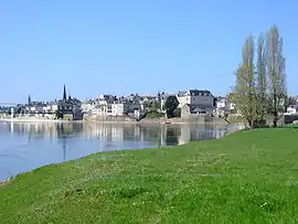
Ingrandes (French pronunciation: [ɛ̃ɡʁɑ̃d] ⓘ) is a former commune in the Maine-et-Loire department, Pays de la Loire, France. On 1 January 2016, it was merged into the new commune of Ingrandes-le-Fresne-sur-Loire.[2]
See also
References
- ↑ Populations légales 2013: Téléchargement du fichier d'ensemble, INSEE
- ↑ Arrêté préfectoral Archived 2016-02-15 at the Wayback Machine 31 December 2015
Wikimedia Commons has media related to Ingrandes (Maine-et-Loire).
This article is issued from Wikipedia. The text is licensed under Creative Commons - Attribution - Sharealike. Additional terms may apply for the media files.