| Irish Law | |
|---|---|
 | |
| Highest point | |
| Elevation | 484 m (1,588 ft) |
| Prominence | 80m |
| Listing | Knockside Hills |
| Naming | |
| Language of name | English |
| Geography | |
| Location | North Ayrshire, Scotland |
| Topo map | OS Landranger 63 |
| Geology | |
| Mountain type | TuMP |
| Climbing | |
| Easiest route | Turn off Largs to A760 access road towards the hill. |
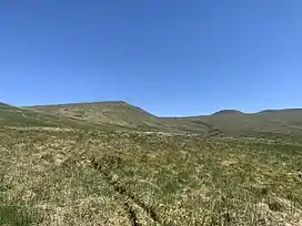
Irish Law is a mountain located in North Ayrshire, Scotland near the town of Largs. It has an elevation of 484 metres (1,588 ft) and a prominence of 80 metres (260 ft), meaning it is categorised as a TuMP.[1]
It has a complex geology, consisting of igneous rocks and vent.[2]
Walkers frequently visit Irish Law to see the wreckage of the downed plane British European Airways Flight S200P which is located on the north side of the hill's slopes.[3][4]
The mountain has no paths leading to it, but it is approximately 1 mile from an access road running from Largs to the A760 road.
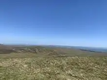
360 panoramic view from the top of Irish Law
References
- ↑ "Irish Law | Scotland". themountainguide.co.uk. Retrieved 2 June 2020.
- ↑ Transactions of the Geological Society of Glasgow. Geological Society of Glasgow. 1928. p. 255.
- ↑ T M Towill, James (2011). Viking Down. AMP Books. pp. 1–2.
- ↑ Wotherspoon, Nick; Clark, Alan; Sheldon, Mark (2009). Aircraft Wrecks: The Walker's Guide : Historic Crash Sites on the Moors and Mountains of the British Isles. Casemate Publishers. p. 255. ISBN 978-1-84415-910-9. Retrieved 3 June 2020.
This article is issued from Wikipedia. The text is licensed under Creative Commons - Attribution - Sharealike. Additional terms may apply for the media files.