Ituma, Mississippi | |
|---|---|
 Ituma  Ituma | |
| Coordinates: 33°13′50″N 90°06′18″W / 33.23056°N 90.10500°W | |
| Country | United States |
| State | Mississippi |
| County | Holmes |
| Elevation | 292 ft (89 m) |
| Time zone | UTC-6 (Central (CST)) |
| • Summer (DST) | UTC-5 (CDT) |
| ZIP code | 39169 |
| Area code | 662 |
| GNIS feature ID | 684305[1] |
Ituma is an unincorporated community located in Holmes County, Mississippi. Ituma is approximately 7 miles (11 km) southwest of Acona and approximately 10 miles (16 km) northeast of Tchula.
Ituma is a name derived from the Choctaw language.[2]
A post office operated under the name Ituma from 1885 to 1914.[3]
References
- ↑ U.S. Geological Survey Geographic Names Information System: Ituma, Mississippi
- ↑ Baca, Keith A. (2007). Native American Place Names in Mississippi. University Press of Mississippi. p. 45. ISBN 978-1-60473-483-6.
- ↑ "Holmes County". Jim Forte Postal History. Retrieved June 3, 2021.
Municipalities and communities of Holmes County, Mississippi, United States | ||
|---|---|---|
| Cities | 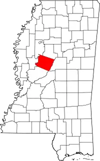 Map of Mississippi highlighting Holmes County | |
| Towns | ||
| Unincorporated communities | ||
| Ghost town | ||
This article is issued from Wikipedia. The text is licensed under Creative Commons - Attribution - Sharealike. Additional terms may apply for the media files.