Jampur Tehsil ضِلع جام پُور | |
|---|---|
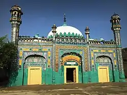 _-_panoramio_(4).jpg.webp) Top: Masjid Deen Muhammad Khan, Jampur View of desert region in the district | |
| Country | |
| Province | |
| Division | Dera Ghazi Khan |
| Established (District Status) | 31 December 2022 |
| Headquarters | Jampur |
| Government | |
| • Type | District Administration |
| • Deputy Commissioner | N/A |
| • District Police Officer | N/A |
| • District Health Officer | N/A |
| Area [1]: 13 | |
| • Total | 12,318 km2 (4,756 sq mi) |
| Population (2017) | |
| • Total | 1,996,039 |
| • Density | 160/km2 (420/sq mi) |
| Time zone | UTC+5 (PST) |
| Number of Tehsils | 3 |
| Main language(s) | Saraiki, Balochi |
| Website | rajanpur |
Jampur (Urdu: ضلع جامپور) is a district of the Pakistani province of Punjab, with its administrative headquarters the city of Jampur.[2] Lying west of the Indus River, its inhabitants are mostly Saraikis and Baloch. According to the 1998 census, the district had a population of 1,100,000, and 14.27% of these were inhabitants of urban areas.[3]
Administration
References
- ↑ 1998 District Census report of Rajanpur. Census publication. Vol. 27. Islamabad: Population Census Organization, Statistics Division, Government of Pakistan. 1999.
- ↑ Correspondent, Our (31 December 2022). "Jampur gets district status". Tribune TODAY'S PAPER. p. 1. Retrieved 2 January 2023.
- ↑ 1998 Census figures – Urban Resource Centre Archived 2006-05-13 at the Wayback Machine
This article is issued from Wikipedia. The text is licensed under Creative Commons - Attribution - Sharealike. Additional terms may apply for the media files.