| Jbel Kissane جبل كيسان ⴰⴷⵔⴰⵔ ⵏ ⴽⵉⵙⴰⵏ | |
|---|---|
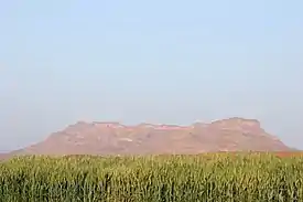 View of Jbel Kissane | |
| Highest point | |
| Elevation | 1,485 m (4,872 ft) |
| Coordinates | 30°42′10″N 06°19′41″W / 30.70278°N 6.32806°W |
| Geography | |
 Jbel Kissane | |
| Parent range | Anti-Atlas |
| Climbing | |
| First ascent | Unknown |
| Easiest route | From Agdz |
Mount Kissane (Jbel Kissane) is a mountain in southeastern Morocco, in the region of Drâa-Tafilalet. It is a distinctive mountain located in the Anti-Atlas range along the valley of the Draa River.[1]
Toponymy
The word Kissane كيسان means "glasses" in Arabic and the mountain is so named because it is deemed to look like the glasses of tea behind a tea pot in the Moroccan style of serving tea.(source?)
Geography
Mount Kissane is a small rocky mountain range with a synclinal pattern.[2] It has a length of 14 km and a maximum width of about 1.8 km. On the top of the mountain there are two ridges cut by a ravine in the middle. There are several peaks; the highest summit is located at the western end of the range, reaching 1485 m.[3]
Importance in the region
The Jbel Kissane is a characteristic mountain whose shape dominates the eastern landscape of the town of Agdz. Its bare rock takes a variety of pastel hues such as pink, salmon and violet, depending from the angle of the sunlight and the time of the day.[4] It is as well a dominant feature of the panoramic views from nearby villages such as Ouliz, Taliouine, Ait Ali, Tinfoula, Aremd, Tisserghate, Ait el Kharj, Igamodene, Tamnougalt, Talate, Talamzit, Timiderte, Ighrghr and Afra.[5]
Features
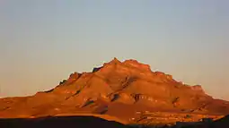 Looking east at Jbel Kissane from Agdz at sunset |
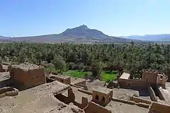 Landscape with the Jbel Kissane in the background |
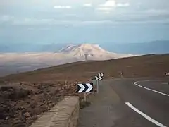 View of Jebel Kissane from the road |
References
External links
 Media related to Jbel Kissane at Wikimedia Commons
- Que faire à Agdz ?
- Through the Tichka
| High Atlas |
|
|---|---|
| Middle Atlas |
|
| Anti-Atlas |
|
| Saharan Atlas |
|
| Rif |
|
| Other peaks & ranges |
|