Joffreville | |
|---|---|
 | |
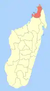
 Joffreville Location in Madagascar | |
| Coordinates: 12°29′S 49°12′E / 12.483°S 49.200°E | |
| Country | |
| Region | Diana |
| District | Antsiranana II |
| Elevation | 634 m (2,080 ft) |
| Population (2009) | |
| • Total | 3,532 |
| Time zone | UTC3 (EAT) |
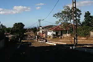
Joffreville or Ambohitra is a town and commune (Malagasy: kaominina) in Madagascar. It belongs to the district of Antsiranana II, which is a part of Diana Region. According to 2009 commune census the population of Joffreville was 3532.
Joffreville is served by a local airport. Primary and junior level secondary education are available in town. The majority 90% of the population are farmers, while an additional 8% receives their livelihood from raising livestock. The most important crops are lychee and vegetables; also banana is an important agricultural product. Industry and services provide both employment for 1% of the population.[2]
References and notes
- ↑ Estimated based on DEM data from Shuttle Radar Topography Mission
- ↑ "ILO census data". Cornell University. 2002. Retrieved 2008-02-13.
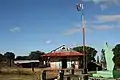 Town hall
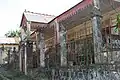 Colonial house
| Ambanja (24) - 203 |
|  |
|---|---|---|
| Ambilobe (15) - 204 | ||
| Antsiranana (Diego Suarez) (1) - 201 | ||
| Antsiranana II (22) - 202 |
| |
| Nosy Be (5) - 207 |
| |
5 districts; 51 communes | ||
12°29′S 49°12′E / 12.483°S 49.200°E
This article is issued from Wikipedia. The text is licensed under Creative Commons - Attribution - Sharealike. Additional terms may apply for the media files.