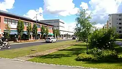
Kaarina
S:t Karins | |
|---|---|
Town | |
| Kaarinan kaupunki S:t Karins stad | |
 | |
 Coat of arms | |
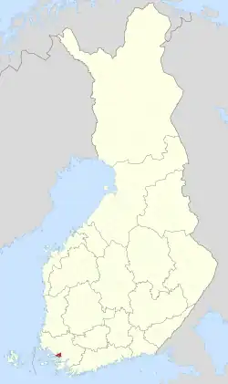 Location of Kaarina in Finland | |
| Coordinates: 60°24′N 022°22′E / 60.400°N 22.367°E | |
| Country | |
| Region | Southwest Finland |
| Sub-region | Turku sub-region |
| Charter | 1869 |
| Government | |
| • Town manager | Harri Virta |
| Area (2018-01-01)[1] | |
| • Total | 179.58 km2 (69.34 sq mi) |
| • Land | 150.57 km2 (58.14 sq mi) |
| • Water | 29.15 km2 (11.25 sq mi) |
| • Rank | 276th largest in Finland |
| Population (2023-09-30)[2] | |
| • Total | 36,266 |
| • Rank | 32nd largest in Finland |
| • Density | 240.86/km2 (623.8/sq mi) |
| Population by native language | |
| • Finnish | 89.3% (official) |
| • Swedish | 4.9% |
| • Others | 5.8% |
| Population by age | |
| • 0 to 14 | 18.5% |
| • 15 to 64 | 60.3% |
| • 65 or older | 21.2% |
| Time zone | UTC+02:00 (EET) |
| • Summer (DST) | UTC+03:00 (EEST) |
| Climate | Dfb |
| Website | www.kaarina.fi |

Kaarina (Finnish pronunciation: [ˈkɑːrinɑ]; Swedish: S:t Karins, i.e. "Saint Catherine's") is a small town and municipality of Finland.
It is located in the Southwest Finland region and is a neighbouring town of Turku, which is the capital of Southwest Finland, therefore Kaarina is a part of the Greater Turku region. The municipality has a population of 36,266 (30 September 2023)[2] and covers an area of 179.58 square kilometres (69.34 sq mi) of which 29.15 km2 (11.25 sq mi) is water.[1] The population density is 240.86 inhabitants per square kilometre (623.8/sq mi).
The municipality is unilingually Finnish, with a Swedish minority and e.g. a Swedish comprehensive school. Bilinguality was proposed but rejected in 2015.
The famous fetish artist Tom of Finland was born in Kaarina. Kaarina has a well known football team Kaarinan Pojat as well as Kino Piispanristi,[6] the largest independent cinema in Southwest Finland.
The municipality of Kuusisto was consolidated with Kaarina in 1946. The municipality of Piikkiö was consolidated with Kaarina on 1 January 2009. At the same time, Kaarina adopted the coat of arms of Piikkiö.
Climate
| Climate data for Kaarina Yltöinen (1991-2020 normals, extremes 1959- present) | |||||||||||||
|---|---|---|---|---|---|---|---|---|---|---|---|---|---|
| Month | Jan | Feb | Mar | Apr | May | Jun | Jul | Aug | Sep | Oct | Nov | Dec | Year |
| Record high °C (°F) | 8.8 (47.8) |
10.0 (50.0) |
14.1 (57.4) |
22.9 (73.2) |
29.3 (84.7) |
31.2 (88.2) |
33.2 (91.8) |
32.2 (90.0) |
26.2 (79.2) |
18.6 (65.5) |
14.1 (57.4) |
11.0 (51.8) |
33.2 (91.8) |
| Mean daily maximum °C (°F) | −0.9 (30.4) |
−1.1 (30.0) |
2.8 (37.0) |
8.9 (48.0) |
15.4 (59.7) |
19.6 (67.3) |
22.5 (72.5) |
21.3 (70.3) |
16.1 (61.0) |
9.3 (48.7) |
4.1 (39.4) |
1.1 (34.0) |
9.9 (49.8) |
| Daily mean °C (°F) | −3.6 (25.5) |
−4.3 (24.3) |
−1.3 (29.7) |
4.0 (39.2) |
10.0 (50.0) |
14.5 (58.1) |
17.5 (63.5) |
16.2 (61.2) |
11.5 (52.7) |
6.0 (42.8) |
1.9 (35.4) |
−1.3 (29.7) |
5.9 (42.6) |
| Mean daily minimum °C (°F) | −6.9 (19.6) |
−7.9 (17.8) |
−5.2 (22.6) |
−0.5 (31.1) |
4.3 (39.7) |
9.1 (48.4) |
12.2 (54.0) |
11.2 (52.2) |
7.2 (45.0) |
2.8 (37.0) |
−0.7 (30.7) |
−4.1 (24.6) |
1.8 (35.2) |
| Record low °C (°F) | −36.7 (−34.1) |
−37.4 (−35.3) |
−30.0 (−22.0) |
−18.4 (−1.1) |
−7.2 (19.0) |
−2.5 (27.5) |
2.0 (35.6) |
−0.6 (30.9) |
−8.0 (17.6) |
−16.8 (1.8) |
−23.5 (−10.3) |
−35.8 (−32.4) |
−37.4 (−35.3) |
| Average precipitation mm (inches) | 54 (2.1) |
41 (1.6) |
37 (1.5) |
32 (1.3) |
35 (1.4) |
57 (2.2) |
71 (2.8) |
78 (3.1) |
56 (2.2) |
74 (2.9) |
67 (2.6) |
68 (2.7) |
671 (26.4) |
| Average precipitation days (≥ 0.1 mm) | 19 | 15 | 13 | 11 | 10 | 12 | 13 | 14 | 13 | 16 | 18 | 20 | 174 |
| Average relative humidity (%) | 92 | 89 | 82 | 75 | 71 | 73 | 77 | 81 | 85 | 89 | 93 | 92 | 83 |
| Source 1: https://helda.helsinki.fi/items/d7ce3a4f-bf47-4453-be76-2a0de738c59a | |||||||||||||
| Source 2: https://kilotavu.com/asema-taulukko.php?asema=100934 | |||||||||||||
Politics
Results of the 2011 Finnish parliamentary election in Kaarina:
- National Coalition Party 29.7%
- Social Democratic Party 21.2%
- True Finns 17.8%
- Left Alliance 9.5%
- Green League 7.1%
- Centre Party 6.6%
- Swedish People's Party 3.4%
- Christian Democrats 2.8%
Images
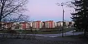 Residential blocks in Kaarina
 Lake Littoistenjärvi
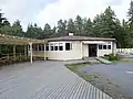 Dance pavilion in Littoinen
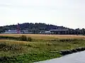 Ravattula
International relations
Twin towns — Sister cities
See also
References
- 1 2 "Area of Finnish Municipalities 1.1.2018" (PDF). National Land Survey of Finland. Retrieved 30 January 2018.
- 1 2 "Preliminary population statistics 2023, September". StatFin. Statistics Finland. Retrieved 26 October 2023.
- ↑ "Demographic Structure by area as of 31 December 2022". Statistics Finland's PX-Web databases. Statistics Finland. Retrieved 6 September 2023.
- ↑ "Population according to age (1-year) and sex by area and the regional division of each statistical reference year, 2003–2020". StatFin. Statistics Finland. Retrieved 2 May 2021.
- ↑
- ↑ "Meistä – Kino Piispanristi". Kino Piispanristi (in Finnish). Retrieved 2022-10-15.
- ↑ "Kaarinalla on viisi ystävyyskaupunkia" (in Finnish). City of Kaarina. 7 April 2015. Archived from the original on 15 December 2014. Retrieved 3 September 2019.
- ↑ "Ukrainan sota katkaisi ystävyyden Kaarinan ja entisen Johanneksen väliltä – Johannes-seuran puheenjohtaja moittii ratkaisua". Kaarina-lehti (in Finnish). 2022-03-08. Retrieved 2023-03-31.
External links
 Kaarina travel guide from Wikivoyage
 Media related to Kaarina at Wikimedia Commons
- Official website
| Municipalities |  | |
|---|---|---|
| Former municipalities |
| |
| ||||||||||||||||||||||||||||||||||||||||||||||||||||||||||||||||||