Kaltenbach | |
|---|---|
 | |
 Coat of arms | |
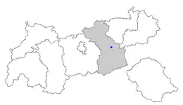 Location of Kaltenbach within Tyrol | |
 Kaltenbach Location within Austria | |
| Coordinates: 47°16′00″N 11°52′00″E / 47.26667°N 11.86667°E | |
| Country | Austria |
| State | Tyrol |
| District | Schwaz |
| Government | |
| • Mayor | Klaus Gasteiger |
| Area | |
| • Total | 12.13 km2 (4.68 sq mi) |
| Elevation | 558 m (1,831 ft) |
| Population (2018-01-01)[2] | |
| • Total | 1,313 |
| • Density | 110/km2 (280/sq mi) |
| Time zone | UTC+1 (CET) |
| • Summer (DST) | UTC+2 (CEST) |
| Postal code | 6272 |
| Area code | 05283 |
| Vehicle registration | SZ |
| Website | www.kaltenbach. tirol.gv.at |
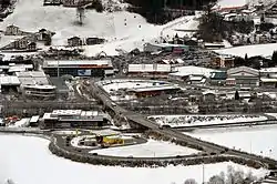
Kaltenbach is a municipality in the Schwaz district in the Austrian state of Tyrol.
Geography
Kaltenbach lies in the central Ziller valley on the left bank of the Ziller, across from Stumm.
References
- ↑ "Dauersiedlungsraum der Gemeinden Politischen Bezirke und Bundesländer - Gebietsstand 1.1.2018". Statistics Austria. Retrieved 10 March 2019.
- ↑ "Einwohnerzahl 1.1.2018 nach Gemeinden mit Status, Gebietsstand 1.1.2018". Statistics Austria. Retrieved 9 March 2019.
Wikimedia Commons has media related to Kaltenbach (Tyrol).
Wikivoyage has a travel guide for Kaltenbach.
This article is issued from Wikipedia. The text is licensed under Creative Commons - Attribution - Sharealike. Additional terms may apply for the media files.