Kapfenstein | |
|---|---|
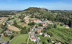 South view of Kapfenstein | |
 Coat of arms | |
 Kapfenstein Location within Austria | |
| Coordinates: 46°53′00″N 15°58′00″E / 46.88333°N 15.96667°E | |
| Country | Austria |
| State | Styria |
| District | Südoststeiermark |
| Government | |
| • Mayor | Franz Nell (ÖVP) |
| Area | |
| • Total | 28.62 km2 (11.05 sq mi) |
| Elevation | 300 m (1,000 ft) |
| Population (2018-01-01)[2] | |
| • Total | 1,557 |
| • Density | 54/km2 (140/sq mi) |
| Time zone | UTC+1 (CET) |
| • Summer (DST) | UTC+2 (CEST) |
| Postal code | 8353 |
| Area code | +43 3157 |
| Vehicle registration | FB |
| Website | www.kapfenstein.at |
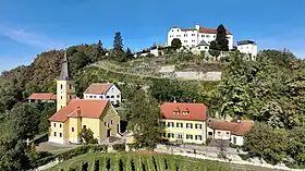
Kapfenstein castle and parish church
Kapfenstein is a municipality in the district of Südoststeiermark in the Austrian state of Styria.
Population
| Year | Pop. | ±% |
|---|---|---|
| 1869 | 2,286 | — |
| 1880 | 2,258 | −1.2% |
| 1890 | 2,299 | +1.8% |
| 1900 | 2,235 | −2.8% |
| 1910 | 2,187 | −2.1% |
| 1923 | 2,112 | −3.4% |
| 1934 | 2,057 | −2.6% |
| 1939 | 1,926 | −6.4% |
| 1951 | 1,877 | −2.5% |
| 1961 | 1,891 | +0.7% |
| 1971 | 1,917 | +1.4% |
| 1981 | 1,880 | −1.9% |
| 1991 | 1,754 | −6.7% |
| 2001 | 1,691 | −3.6% |
| 2013 | 1,615 | −4.5% |
References
- ↑ "Dauersiedlungsraum der Gemeinden Politischen Bezirke und Bundesländer - Gebietsstand 1.1.2018". Statistics Austria. Retrieved 10 March 2019.
- ↑ "Einwohnerzahl 1.1.2018 nach Gemeinden mit Status, Gebietsstand 1.1.2018". Statistics Austria. Retrieved 9 March 2019.
External links
This article is issued from Wikipedia. The text is licensed under Creative Commons - Attribution - Sharealike. Additional terms may apply for the media files.