Katanga Slum | |
|---|---|
| Country | |
| Region | Central Uganda |
| District | Kampala District |
| Division | Kampala Central Division |
| Time zone | EAT |
Katanga Slum is a settlement located in the valley between Mulago Hospital and Makerere University, in Uganda's capital city, Kampala.[1][2]
Location
Katanga slum is located in Kawempe Division. It is bordered by Bwaise to the north, Mulago to the east, Wandegeya to the west, and Nakasero to the south.[3]
Overview
Katanga slum stretches about 1.5 kilometres from Wandegeya to Kubiri, near Bwaise. Katanga is divided into two administrative Local Council 1 zone, "Busia zone" and "Kimwanyi zone". It is developed with students hostels as viewed from Wandegeya, and temporary structures built with timber or mud and bricks. The temporary structures are mostly close to Mulago hospital.[4]
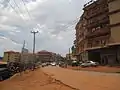 Hostels in Katanga
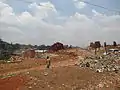 Brick making in Katanga
 Katanga 2
 Katanga 3
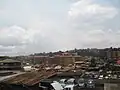 Katanga from Mulago
 Katanga from Mulago
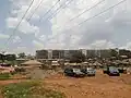 Katanga near Mulago
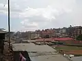 Katanga showing hostels and mud houses
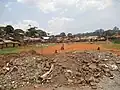 Katanga with a playground
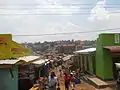 Shops in katanga near Mulago
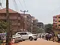 Students hostels in Katanga
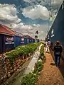 Access road with drainage channel
References
- ↑ "The bright tones of Katanga" startjournal.org. Retrieved March 16, 2015
- ↑ "Mapping Katanga in Kampala" sites.google.com. Retrieved March 16, 2015
- ↑ "Katanga Slum " maps.google.com. Retrieved March 16, 2015
- ↑ "A Day in Katanga" ugpulse.com. Retrieved March 16, 2015
External links
This article is issued from Wikipedia. The text is licensed under Creative Commons - Attribution - Sharealike. Additional terms may apply for the media files.