Kenwood, Oklahoma | |
|---|---|
 Kenwood | |
| Coordinates: 36°18′04″N 94°59′52″W / 36.30111°N 94.99778°W[1] | |
| Country | United States |
| State | Oklahoma |
| Counties | Delaware, Mayes |
| Area | |
| • Total | 45.06 sq mi (116.70 km2) |
| • Land | 45.06 sq mi (116.70 km2) |
| • Water | 0.00 sq mi (0.00 km2) |
| Elevation | 814 ft (248 m) |
| Population (2020) | |
| • Total | 904 |
| • Density | 20.06/sq mi (7.75/km2) |
| Time zone | UTC-6 (Central (CST)) |
| • Summer (DST) | UTC-5 (CDT) |
| Area code(s) | 539/918 |
| GNIS feature ID | 2584383[1] |
| FIPS code | 40-39450 |
Kenwood is an unincorporated community and census-designated place (CDP) in Delaware and Mayes counties, Oklahoma, United States. As of the 2010 census it had a population of 1,224.[3]
Kenwood is 20 miles (32 km) by road southwest of Jay, the Delaware County seat. It is 11 miles (18 km) east of Salina. Kenwood once had a post office, which opened on May 25, 1922. The community's name came from a combination of William Kennedy and the National Hardwood Company.[4]
Demographics
| Census | Pop. | Note | %± |
|---|---|---|---|
| 2020 | 904 | — | |
| U.S. Decennial Census[5] | |||
References
- 1 2 3 U.S. Geological Survey Geographic Names Information System: Kenwood, Oklahoma
- ↑ "ArcGIS REST Services Directory". United States Census Bureau. Retrieved September 20, 2022.
- ↑ "Geographic Identifiers: 2010 Demographic Profile Data (G001): Kenwood CDP, Oklahoma". U.S. Census Bureau, American Factfinder. Archived from the original on February 13, 2020. Retrieved December 10, 2015.
- ↑ Shirk, George (1987). Oklahoma Place Names. University of Oklahoma Press. p. 27. ISBN 9780806120287.
- ↑ "Census of Population and Housing". Census.gov. Retrieved June 4, 2016.
Municipalities and communities of Delaware County, Oklahoma, United States | ||
|---|---|---|
| Cities | 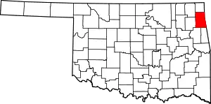 Delaware County map | |
| Towns | ||
| CDPs | ||
| Other communities | ||
| Indian reservation | ||
| Footnotes | ‡This populated place also has portions in an adjacent county or counties | |
This article is issued from Wikipedia. The text is licensed under Creative Commons - Attribution - Sharealike. Additional terms may apply for the media files.