Kigoma
| |
|---|---|
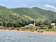
 Fishing boat in Kalalangabo village, Kagongo Ward, Kigoma District | |
| Nickname: Home to Gombe National Park | |
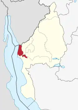 Kigoma District in Kigoma Region | |
| Coordinates: 04°41′26.88″S 29°42′49.68″E / 4.6908000°S 29.7138000°E | |
| Country | |
| Region | Kigoma Region |
| Area | |
| • Total | 967.7 km2 (373.6 sq mi) |
| Population | |
| • Total | 267,712 |
| • Density | 280/km2 (720/sq mi) |
| Demonym | District Kigoman |
| Postcode | 472xx |
| Area code | 028 |
| Website | District Website |

Kigoma District is one of the eight administrative districts of Kigoma Region in Tanzania. The district lies north of the city of Kigoma-Ujiji. Uvinza District, to the west and south of Ujiji, was split off from the Kigoma District in 1 July, 2013.[2]
Geography
The District covers an area of 967.7 km2 (373.6 sq mi), which is about 20.8% of the region's total area. It is bordered to the west by Lake Tanganyika. The district is bordered by Buhigwe District and Kasulu District to the east; Kigoma-Ujiji District and Uvinza District to the south.[3][4]
Demographics
In 2016 the Tanzania National Bureau of Statistics report there were 267,712 people in the district, from 211,566 in 2012.[1]: 125 [5]: 147
The district is of the tribes of Waha, Wabembe, Goma people, Wabwari, and Watongwe. Waha are the largest tribe, making up 95% of the people.[6]: 2
Administrative subdivisions
Kigoma District was administratively divided into 16 Ward, 46 villages, and 212 hamlets.[7][1]: 125 [4]
Wards
References
- 1 2 3 2016 Makadirio ya Idadi ya Watu katika Majimbo ya Uchaguzi kwa Mwaka 2016, Tanzania Bara [Population Estimates in Administrative Areas for the Year 2016, Mainland Tanzania] (PDF) (Report) (in Swahili). Dar es Salaam, Tanzania: National Bureau of Statistics. 2016-04-01. Archived (PDF) from the original on 2021-12-27. Retrieved 2022-07-03.
- ↑ "Historia". Halmashauri ya Wilaya ya Uvinza (in Swahili). Uvinza District: Uvinza District. Archived from the original on 24 June 2022. Retrieved 15 August 2022.
- ↑ "Tanzania: Lake Zone(Districts and Wards) - Population Statistics, Charts and Map".
- 1 2 "Historia". Halmashauri ya Wilaya ya Kigoma (in Swahili). Kigoma District: Kigoma District. Archived from the original on 16 June 2022. Retrieved 15 August 2022.
- ↑ 2012 Population and Housing Census - Population Distribution by Administrative Areas (PDF) (Report). Dar es Salaam, Tanzania: National Bureau of Statistics. 2013-03-01. Archived (PDF) from the original on 2022-03-26. Retrieved 2022-07-03.
- ↑ Kigoma District Strategic Plan (PDF) (District Plan). Kigoma District: Kigoma District. 2016. Archived (PDF) from the original on 16 June 2022. Retrieved 15 August 2022.
- ↑ "Kagera Postcodes" (PDF). Dodoma, Tanzania: Tanzania Communications Regulatory Authority. Archived (PDF) from the original on 29 July 2022. Retrieved 13 August 2022.