Kolsassberg | |
|---|---|
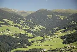 View of Kolsassberg and Innerweerberg | |
 Coat of arms | |
 Kolsassberg Location within Austria | |
| Coordinates: 47°16′57″N 11°39′06″E / 47.28250°N 11.65167°E | |
| Country | Austria |
| State | Tyrol |
| District | Innsbruck Land |
| Government | |
| • Mayor | Josef Gruber |
| Area | |
| • Total | 35.37 km2 (13.66 sq mi) |
| Elevation | 906 m (2,972 ft) |
| Population (2018-01-01)[2] | |
| • Total | 817 |
| • Density | 23/km2 (60/sq mi) |
| Time zone | UTC+1 (CET) |
| • Summer (DST) | UTC+2 (CEST) |
| Postal code | 6114 |
| Area code | 05224 |
| Vehicle registration | IL |
| Website | www.kolsassberg.tirol.gv.at |
Kolsassberg is a municipality in the district Innsbruck-Land in the Austrian state of Tyrol located about 19 km east of Innsbruck and 2 km above Kolsass. The location was founded around 1196.
Population
| Year | Pop. | ±% |
|---|---|---|
| 1869 | 384 | — |
| 1880 | 367 | −4.4% |
| 1890 | 347 | −5.4% |
| 1900 | 358 | +3.2% |
| 1910 | 375 | +4.7% |
| 1923 | 367 | −2.1% |
| 1934 | 400 | +9.0% |
| 1939 | 378 | −5.5% |
| 1951 | 377 | −0.3% |
| 1961 | 380 | +0.8% |
| 1971 | 454 | +19.5% |
| 1981 | 510 | +12.3% |
| 1991 | 568 | +11.4% |
| 2001 | 721 | +26.9% |
| 2011 | 742 | +2.9% |
References
- ↑ "Dauersiedlungsraum der Gemeinden Politischen Bezirke und Bundesländer - Gebietsstand 1.1.2018". Statistics Austria. Retrieved 10 March 2019.
- ↑ "Einwohnerzahl 1.1.2018 nach Gemeinden mit Status, Gebietsstand 1.1.2018". Statistics Austria. Retrieved 9 March 2019.
External links
Wikimedia Commons has media related to Kolsassberg.
This article is issued from Wikipedia. The text is licensed under Creative Commons - Attribution - Sharealike. Additional terms may apply for the media files.