Lémeré | |
|---|---|
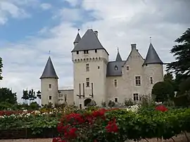 Chateau of Rivau | |
Location of Lémeré | |
 Lémeré  Lémeré | |
| Coordinates: 47°05′01″N 0°20′09″E / 47.0836°N 0.3358°E | |
| Country | France |
| Region | Centre-Val de Loire |
| Department | Indre-et-Loire |
| Arrondissement | Chinon |
| Canton | Sainte-Maure-de-Touraine |
| Government | |
| • Mayor (2020–2026) | Martine Juszczak[1] |
| Area 1 | 19.83 km2 (7.66 sq mi) |
| Population | 453 |
| • Density | 23/km2 (59/sq mi) |
| Time zone | UTC+01:00 (CET) |
| • Summer (DST) | UTC+02:00 (CEST) |
| INSEE/Postal code | 37125 /37120 |
| Elevation | 35–115 m (115–377 ft) |
| 1 French Land Register data, which excludes lakes, ponds, glaciers > 1 km2 (0.386 sq mi or 247 acres) and river estuaries. | |
Lémeré (French pronunciation: [lemʁe]) is a commune in the Indre-et-Loire department in central France.
Population
| Year | Pop. | ±% p.a. |
|---|---|---|
| 1968 | 479 | — |
| 1975 | 436 | −1.33% |
| 1982 | 380 | −1.94% |
| 1990 | 365 | −0.50% |
| 1999 | 369 | +0.12% |
| 2007 | 401 | +1.04% |
| 2012 | 475 | +3.45% |
| 2017 | 518 | +1.75% |
| Source: INSEE[3] | ||
See also
References
- ↑ "Répertoire national des élus: les maires". data.gouv.fr, Plateforme ouverte des données publiques françaises (in French). 2 December 2020.
- ↑ "Populations légales 2021". The National Institute of Statistics and Economic Studies. 28 December 2023.
- ↑ Population en historique depuis 1968, INSEE
Wikimedia Commons has media related to Lémeré.
This article is issued from Wikipedia. The text is licensed under Creative Commons - Attribution - Sharealike. Additional terms may apply for the media files.