La Chapelle-Yvon | |
|---|---|
Part of Valorbiquet | |
Location of La Chapelle-Yvon | |
 La Chapelle-Yvon  La Chapelle-Yvon | |
| Coordinates: 49°03′53″N 0°20′27″E / 49.0647°N 0.3408°E | |
| Country | France |
| Region | Normandy |
| Department | Calvados |
| Arrondissement | Lisieux |
| Canton | Livarot-Pays-d'Auge |
| Commune | Valorbiquet |
| Area 1 | 7.01 km2 (2.71 sq mi) |
| Population (2019)[1] | 549 |
| • Density | 78/km2 (200/sq mi) |
| Time zone | UTC+01:00 (CET) |
| • Summer (DST) | UTC+02:00 (CEST) |
| Postal code | 14290 |
| Elevation | 71–169 m (233–554 ft) (avg. 91 m or 299 ft) |
| 1 French Land Register data, which excludes lakes, ponds, glaciers > 1 km2 (0.386 sq mi or 247 acres) and river estuaries. | |
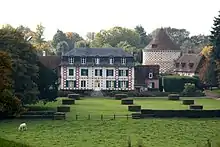
Château du Besneray
La Chapelle-Yvon (French pronunciation: [la ʃapɛl ivɔ̃] ⓘ) is a former commune in the Calvados department in the Normandy region in northwestern France. On 1 January 2016, it was merged into the new commune of Valorbiquet.[2]
Population
| Year | Pop. | ±% |
|---|---|---|
| 1962 | 448 | — |
| 1968 | 440 | −1.8% |
| 1975 | 384 | −12.7% |
| 1982 | 437 | +13.8% |
| 1990 | 525 | +20.1% |
| 1999 | 499 | −5.0% |
| 2008 | 508 | +1.8% |
See also
References
- ↑ Téléchargement du fichier d'ensemble des populations légales en 2019, INSEE
- ↑ Arrêté préfectoral 9 December 2015 (in French)
Wikimedia Commons has media related to La Chapelle-Yvon.
This article is issued from Wikipedia. The text is licensed under Creative Commons - Attribution - Sharealike. Additional terms may apply for the media files.