La Lisa | |
|---|---|
 | |
 Seal | |
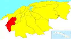 Location of La Lisa in Havana | |
| Coordinates: 23°01′29″N 82°27′47″W / 23.02472°N 82.46306°W | |
| Country | |
| Province | |
| Wards (Consejos Populares) | Alturas de La Lisa, Arroyo Arenas, Balcón Arimao, El Cano-Valle Grande-Bello 26 y Morado, Punta Brava, San Agustín, Versalles-Coronela |
| Government | |
| • President | Yoamel Acosta Morales |
| Area | |
| • Total | 37.5 km2 (14.5 sq mi) |
| Population (2004)[2] | |
| • Total | 130,969 |
| • Density | 3,492.5/km2 (9,046/sq mi) |
| Time zone | UTC-5 (EST) |
| Area code | +53-7 |
La Lisa (Spanish pronunciation: [la ˈlisa]) is one of the 15 municipalities or boroughs (municipios in Spanish) in the city of Havana, Cuba.
Overview
It has 7 neighbourhoods:
- Alturas de La Lisa
- Arroyo Arenas
- Balcón Arimao
- El Cano-Valle Grande-Bello 26 y Morado
- Punta Brava
- San Agustín
- Versalles-Coronela.
It can be generally thought of as a semi-rural municipality.
References
- ↑ Statoids (July 2003). "Municipios of Cuba". Retrieved 2007-10-06.
- ↑ Atenas.cu (2004). "2004 Population trends, by Province and Municipality" (in Spanish). Archived from the original on 2006-07-14. Retrieved 2007-10-06.
External links
 Media related to La Lisa at Wikimedia Commons
| Arroyo Naranjo |
| |
|---|---|---|
| Boyeros |
| |
| Centro Habana |
| |
| Cerro |
| |
| Cotorro |
| |
| Diez de Octubre | ||
| Guanabacoa |
| |
| La Habana del Este |
| |
| La Habana Vieja |
| |
| La Lisa |
| |
| Marianao |
| |
| Playa |
| |
| Plaza de la Revolución |
| |
| Regla |
| |
| San Miguel del Padrón |
| |
This article is issued from Wikipedia. The text is licensed under Creative Commons - Attribution - Sharealike. Additional terms may apply for the media files.