Lake Boga | ||||||||||||||||
|---|---|---|---|---|---|---|---|---|---|---|---|---|---|---|---|---|
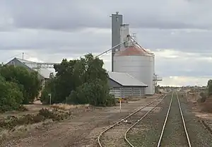 Silos and siding at Lake Boga looking towards Swan Hill | ||||||||||||||||
| General information | ||||||||||||||||
| Line(s) | Yungera | |||||||||||||||
| Platforms | 1 | |||||||||||||||
| Tracks | 2 | |||||||||||||||
| Other information | ||||||||||||||||
| Status | Closed | |||||||||||||||
| History | ||||||||||||||||
| Closed | 4 October 1981 | |||||||||||||||
| Services | ||||||||||||||||
| ||||||||||||||||
Lake Boga railway station was located on the Yungera line. It served the Victoria town of Lake Boga. The station closed to passenger traffic on 4 October 1981 as part of the New Deal timetable for country passengers.[1] A siding and a number of grain silos remain at the site.
References
- ↑ Scott Martin and Chris Banger (October 2006). "'New Deal' for County Passengers – 25 years on". Newsrail. Australian Railway Historical Society (Victorian Division). p. 319.
External links
- Melway map at street-directory.com.au
35°27′39″S 143°37′55″E / 35.4607°S 143.6319°E
This article is issued from Wikipedia. The text is licensed under Creative Commons - Attribution - Sharealike. Additional terms may apply for the media files.