Langerwehe | |
|---|---|
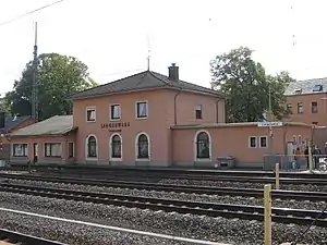 Train station | |
 Coat of arms | |
Location of Langerwehe within Düren district 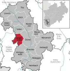 | |
 Langerwehe  Langerwehe | |
| Coordinates: 50°49′00″N 06°20′59″E / 50.81667°N 6.34972°E | |
| Country | Germany |
| State | North Rhine-Westphalia |
| Admin. region | Köln |
| District | Düren |
| Subdivisions | 14 |
| Government | |
| • Mayor (2020–25) | Peter Münstermann[1] (SPD) |
| Area | |
| • Total | 41.49 km2 (16.02 sq mi) |
| Elevation | 158 m (518 ft) |
| Population (2021-12-31)[2] | |
| • Total | 14,050 |
| • Density | 340/km2 (880/sq mi) |
| Time zone | UTC+01:00 (CET) |
| • Summer (DST) | UTC+02:00 (CEST) |
| Postal codes | 52379 |
| Dialling codes | 02423 |
| Vehicle registration | DN |
| Website | www.langerwehe.de |
Langerwehe is a municipality in the district of Düren in the state of North Rhine-Westphalia, Germany. It is located approximately 10 km west of Düren. It is a twin town of Exmouth, United Kingdom.
Nearby is Holzheim Castle, now a farm and riding stables.
.JPG.webp)
Holzheim castle
References
Wikimedia Commons has media related to Langerwehe.
- ↑ Wahlergebnisse in NRW Kommunalwahlen 2020, Land Nordrhein-Westfalen, accessed 19 June 2021.
- ↑ "Bevölkerung der Gemeinden Nordrhein-Westfalens am 31. Dezember 2021" (in German). Landesbetrieb Information und Technik NRW. Retrieved 20 June 2022.
Towns and municipalities in Düren (district) | ||
|---|---|---|
Coat of Arms of Düren district | ||
This article is issued from Wikipedia. The text is licensed under Creative Commons - Attribution - Sharealike. Additional terms may apply for the media files.