| Langtang Ri | |
|---|---|
 | |
| Highest point | |
| Elevation | 7,205 m (23,638 ft)[1] Ranked 106th |
| Prominence | 650 m (2,130 ft)[1] |
| Parent peak | Shishapangma |
| Coordinates | 28°22′53″N 85°41′01″E / 28.38139°N 85.68361°E |
| Geography | |
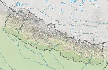 Langtang Ri Location in Nepal, on the border with China | |
| Location | China–Nepal border |
| Parent range | Langtang Himal, Himalayas |
| Climbing | |
| First ascent | October 1981 by a Japanese team[2] |
| Easiest route | rock/snow/ice climb |
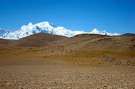
Langtang Ri is a mountain in the Langtang Himal of the Himalayas. At an elevation of 7,205 m (23,638 ft) it is the 106th highest mountain in the world. Located on the border between the Bagmati Zone of Nepal and Tibet, China, it is part of a group of high peaks that include Shishapangma (8,013 m) and Porong Ri (7,292 m).
Langtang Ri was first climbed on 10 October 1981 by a Japanese expedition.
See also
References
- 1 2 "Langtang Ri, China/Nepal". Peakbagger.com. Retrieved 2014-08-10.
- ↑ "High Asia summits over 6,750 metres high with 500 metres of re-ascent". viewfinderpanoramas.org. Retrieved 2014-08-10.
This article is issued from Wikipedia. The text is licensed under Creative Commons - Attribution - Sharealike. Additional terms may apply for the media files.