Lederach, Pennsylvania | |
|---|---|
Unincorporated community | |
 Lederach | |
| Coordinates: 40°15′42″N 75°24′22″W / 40.26167°N 75.40611°W | |
| Country | United States |
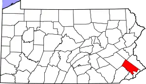
| State | Pennsylvania |
| County | Montgomery |
| Township | Lower Salford |
| Elevation | 367 ft (112 m) |
| Time zone | UTC-5 (Eastern (EST)) |
| • Summer (DST) | UTC-4 (EDT) |
| ZIP code | 19450 |
| Area code(s) | 215, 267 and 445 |
| GNIS feature ID | 1179109[1] |
Lederach is an unincorporated community in Lower Salford Township in Montgomery County, Pennsylvania, United States. Lederach is located at the intersection of Pennsylvania Route 113, Salfordville Road/Morris Road, Old Skippack Road, and Cross Road.[2]
References
- ↑ "Lederach". Geographic Names Information System. United States Geological Survey, United States Department of the Interior.
- ↑ Montgomery County, Pennsylvania Highway Map (PDF) (Map). PennDOT. 2015. Retrieved January 12, 2016.
This article is issued from Wikipedia. The text is licensed under Creative Commons - Attribution - Sharealike. Additional terms may apply for the media files.