Lez | |
|---|---|
Part of Saint-Béat-Lez | |
 | |
Location of Lez | |
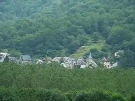
 Lez  Lez | |
| Coordinates: 42°54′36″N 0°42′06″E / 42.91°N 0.7017°E | |
| Country | France |
| Region | Occitania |
| Department | Haute-Garonne |
| Arrondissement | Saint-Gaudens |
| Canton | Bagnères-de-Luchon |
| Commune | Saint-Béat-Lez |
| Area 1 | 2.6 km2 (1.0 sq mi) |
| Population (2019)[1] | 60 |
| • Density | 23/km2 (60/sq mi) |
| Time zone | UTC+01:00 (CET) |
| • Summer (DST) | UTC+02:00 (CEST) |
| Postal code | 31440 |
| Elevation | 499–1,180 m (1,637–3,871 ft) (avg. 505 m or 1,657 ft) |
| 1 French Land Register data, which excludes lakes, ponds, glaciers > 1 km2 (0.386 sq mi or 247 acres) and river estuaries. | |
Lez (French pronunciation: [lɛz]; Gascon: Les) is a former commune in the Haute-Garonne department in southwestern France. On 1 January 2019, it was merged into the new commune Saint-Béat-Lez.[2]
Population
| Year | Pop. | ±% |
|---|---|---|
| 1962 | 135 | — |
| 1968 | 154 | +14.1% |
| 1975 | 110 | −28.6% |
| 1982 | 75 | −31.8% |
| 1990 | 72 | −4.0% |
| 1999 | 67 | −6.9% |
| 2008 | 60 | −10.4% |
| 2017 | 59 | −1.7% |
See also
References
- ↑ Téléchargement du fichier d'ensemble des populations légales en 2019, INSEE
- ↑ Arrêté préfectoral 30 April 2018 (in French)
Wikimedia Commons has media related to Lez (Haute-Garonne).
This article is issued from Wikipedia. The text is licensed under Creative Commons - Attribution - Sharealike. Additional terms may apply for the media files.