Mukim Liang | |
|---|---|
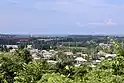 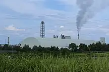 .jpg.webp) 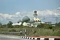 Clockwise from top left: Lumut, Sungai Liang Industrial Park, Zainab Mosque, Sungai Liang | |
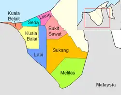 Liang is in pink. | |
| Coordinates: 4°39′36″N 114°27′32″E / 4.66000°N 114.45889°E | |
| Country | Brunei |
| District | Belait |
| Government | |
| • Penghulu | Haszrin Bagol[1] |
| Population (2016)[2] | |
| • Total | 14,301 |
| Time zone | UTC+8 (BNT) |
| Postcode | KCxx35 |
Mukim Liang is a mukim in Belait District, Brunei.[3] The population was 14,301 in 2016.[2]
Geography
The mukim is located in the north of the district, bordering the South China Sea to the north, Mukim Telisai in Tutong District to the north-east, Mukim Bukit Sawat to the south-east, Mukim Labi to the south and Mukim Seria to the west.[4]
Demographics
As of 2016 census,[2] the population was 14,301 with 51.4% males and 48.6% females. The mukim had 2,607 households occupying 2,602 dwellings. Among the population, 32.3% lived in urban areas, while the remainder of 67.7% lived in rural areas.
Villages
As of 2016, the mukim comprised the following census villages:[2]
| Village | Population (2016) |
|---|---|
| Kampong Agis-Agis | 270 |
| Kampong Keluyoh | 206 |
| Kampong Lilas | 223 |
| Kampong Lumut | 233 |
| Kampong Lumut Tersusun | 1,020 |
| Kampong Perumpong | 523 |
| Kampong Sungai Bakong | 1,451 |
| Kampong Sungai Gana | 342 |
| Kampong Sungai Kang | 113 |
| Kampong Sungai Kuru | 352 |
| Kampong Sungai Lalit | 369 |
| Kampong Sungai Liang | 910 |
| Kampong Sungai Tali | 1,051 |
| Kampong Sungai Taring | 982 |
| Kampong Tunggulian | 824 |
| Perkhemahan Lumut ("Lumut Camp") | 811 |
| RPN Lumut Area 1 | 2,040 |
| RPN Lumut Area 2 | 2,581 |
| Total | 14,301 |
The villages above are currently grouped into three areas and each is overseen by a village head (ketua kampung). The areas include:
- Kampong Lumut I
- Kampong Lumut II
- Kampong Sungai Liang
References
- ↑ "Direktori Penghulu, Ketua Kampung, dan Ketua Rumah Panjang - Awang Mohammad Haszrin Bin Bagol". www.belait.gov.bn. Retrieved 11 January 2023.
- 1 2 3 4 "Population and Housing Census Update Final Report 2016" (PDF). www.deps.gov.bn. Statistics Department. December 2018. Retrieved 27 June 2021.
- ↑ "Belait District" (PDF). www.information.gov.bn. 2011. pp. 8–9. Retrieved 28 June 2021.
- ↑ Brunei Darussalam street directory : quick & easy reference maps., Brunei. Juruukur Agung., Brunei Press Sdn. Bhd., Published & printed by Brunei Press Sdn. Bhd., Commercial Printing Services, 2014, ISBN 9789991732411, OCLC 932264901
{{citation}}: CS1 maint: others (link)