Mukim Keriam | |
|---|---|
 Kampong Keriam | |
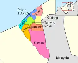 Keriam is in red. | |
| Coordinates: 4°49′17″N 114°43′37″E / 4.8213237°N 114.7268464°E | |
| Country | Brunei |
| District | Tutong |
| Population (2016)[1] | |
| • Total | 9,707 |
| Time zone | UTC+8 (BNT) |
| Postcode | TBxx41 |
Mukim Keriam is a mukim in Tutong District, Brunei. The population was 9,707 in 2016.[1]
Name
The mukim is named after Kampong Keriam, one of the villages it encompasses.
Geography
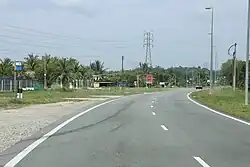
The mukim is located in the north-east of Tutong District, bordering the South China Sea to the north, Mukim Sengkurong and Mukim Pengkalan Batu in Brunei-Muara District to the east, Mukim Kiudang to the south, and Mukim Pekan Tutong to the west.[2]
Demographics
As of 2016 census,[1] the population was 9,707 with 52.6% males and 47.4% females. It had 1,773 households occupying 1,762 dwellings. The mukim is predominantly rural, with 83.3% living in rural areas.
Administration
As of 2016, the mukim comprised the following census villages:[1]
| Village | Population (2016) |
|---|---|
| Kampong Bukit Panggal | 801 |
| Kampong Ikas | 68 |
| Kampong Keriam | 2,195 |
| Kampong Kupang | 1,795 |
| Kampong Luagan Dudok | 879 |
| Kampong Maraburong | 520 |
| Kampong Sinaut | 932 |
| Kampong Sungai Kelugos | 900 |
| Padang Tembak Binturan | 1,617 |
| Total | 9.707 |
References
- 1 2 3 4 "Population and Housing Census Update Final Report 2016" (PDF). www.deps.gov.bn. Statistics Department. December 2018. Retrieved 27 June 2021.
- ↑ "Geoportal - Survey Department". survey.gov.bn. Retrieved 14 December 2017.
This article is issued from Wikipedia. The text is licensed under Creative Commons - Attribution - Sharealike. Additional terms may apply for the media files.