Linguang BR06 麟光 | |||||||||||||||||
|---|---|---|---|---|---|---|---|---|---|---|---|---|---|---|---|---|---|
 Linguang station platform | |||||||||||||||||
| Chinese name | |||||||||||||||||
| Chinese | 麟光 | ||||||||||||||||
| |||||||||||||||||
| General information | |||||||||||||||||
| Location | No. 410, Sec. 3, Heping E. Rd. Da’an and Xinyi, Taipei Taiwan | ||||||||||||||||
| Operated by | Taipei Metro | ||||||||||||||||
| Line(s) | |||||||||||||||||
| Connections | Bus stop | ||||||||||||||||
| Construction | |||||||||||||||||
| Structure type | Elevated | ||||||||||||||||
| Other information | |||||||||||||||||
| Station code | BR06 | ||||||||||||||||
| History | |||||||||||||||||
| Opened | 28 March 1996 | ||||||||||||||||
| Passengers | |||||||||||||||||
| daily (December 2020)[1] | |||||||||||||||||
| Rank | 71 out of 109 and 5 others | ||||||||||||||||
| Services | |||||||||||||||||
| |||||||||||||||||
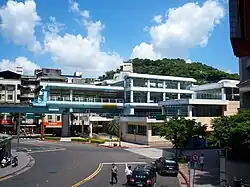
Linguang station (formerly transliterated as Linkuang Station until 2003) is a station on the Brown Line of the Taipei Metro, located on the border of Taipei, Taiwan.
Station overview
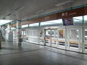
Linguang station.
The three-level, elevated station has two side platforms, and a single exit.[2]
Station layout
| 4F | Connecting Level | Platforms-connecting Overpass |
| 3F | ||
| Side platform, doors will open on the right | ||
| Platform 1 | ← | |
| Platform 2 | → | |
| Side platform, doors will open on the right | ||
| 1F | Concourse Level | Exit/Entrance, Lobby, information desk, automatic ticket dispensing machines, one-way faregates, restrooms |
Exits
- Single Exit: On Heping East Rd.

Around the station
- Coastal Patrol Directorate General
- Linguang New Community
- Fuyang Natural Ecological Park
- Fuzhoushan Park
- Lizhong Park
- Taipei Muslim Cemetery
References
Wikimedia Commons has media related to Linguang Station.
- ↑ "Passenger Volume at Taipei Rapid Transit Stations". Taipei Mass Rapid Transit Co., Ltd. 2021-01-15.
- ↑ "Route Map: Linguang". Taipei Rapid Transit Corporation. Archived from the original on 2011-09-02. Retrieved 2010-06-09.
| Stations |
| ||||
|---|---|---|---|---|---|
| Rolling stock |
| ||||
25°01′06″N 121°33′32″E / 25.018328°N 121.55878°E
This article is issued from Wikipedia. The text is licensed under Creative Commons - Attribution - Sharealike. Additional terms may apply for the media files.