Litohoř | |
|---|---|
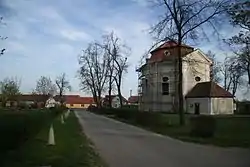 Centre with Church of Saint John of Nepomuk | |
 Flag  Coat of arms | |
 Litohoř Location in the Czech Republic | |
| Coordinates: 49°4′0″N 15°46′6″E / 49.06667°N 15.76833°E | |
| Country | |
| Region | Vysočina |
| District | Třebíč |
| First mentioned | 1190 |
| Area | |
| • Total | 7.50 km2 (2.90 sq mi) |
| Elevation | 464 m (1,522 ft) |
| Population (2023-01-01)[1] | |
| • Total | 562 |
| • Density | 75/km2 (190/sq mi) |
| Time zone | UTC+1 (CET) |
| • Summer (DST) | UTC+2 (CEST) |
| Postal code | 675 46 |
| Website | www |
Litohoř is a municipality and village in Třebíč District in the Vysočina Region of the Czech Republic. It has about 600 inhabitants.
Litohoř lies approximately 19 kilometres (12 mi) south-west of Třebíč, 39 km (24 mi) south of Jihlava, and 150 km (93 mi) south-east of Prague.
References
Wikimedia Commons has media related to Litohoř.
This article is issued from Wikipedia. The text is licensed under Creative Commons - Attribution - Sharealike. Additional terms may apply for the media files.