40°56′20″N 44°46′21″E / 40.93889°N 44.77250°E
Lorut
Լորուտ | |
|---|---|
 | |
 Lorut | |
| Coordinates: 40°56′20″N 44°46′21″E / 40.93889°N 44.77250°E | |
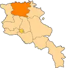
| Country | Armenia |
| Marz (Province) | Lori |
| Elevation | 1,499 m (4,918 ft) |
| Population (2008) | |
| • Total | 1,196 |
| Time zone | UTC+4 ( ) |
Lorut (Armenian: Լորուտ), is a village in the Lori Province of Armenia. It belongs to the municipality of Tumanyan.
References
- Lorut at GEOnet Names Server
- World Gazeteer: Armenia – World-Gazetteer.com
- Report of the results of the 2001 Armenian Census, Statistical Committee of Armenia
This article is issued from Wikipedia. The text is licensed under Creative Commons - Attribution - Sharealike. Additional terms may apply for the media files.