Lost Springs Township Marion County, Kansas | |
|---|---|
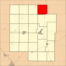 Location within Marion County | |
 Lost Springs Township Marion County, Kansas Location within the state of Kansas | |
| Coordinates: 38°33′57″N 96°59′07″W / 38.5657369°N 96.9853574°W[1] | |
| Country | United States |
| State | Kansas |
| County | Marion |
| Area | |
| • Total | 36 sq mi (90 km2) |
| Dimensions | |
| • Length | 6.0 mi (9.7 km) |
| • Width | 6.0 mi (9.7 km) |
| Elevation | 1,457 ft (444 m) |
| Population | |
| • Total | 197 |
| • Density | 5.5/sq mi (2.1/km2) |
| Time zone | UTC-6 (CST) |
| • Summer (DST) | UTC-5 (CDT) |
| Area code | 620 |
| FIPS code | 20-42850 [1] |
| GNIS ID | 477137 [1] |
| Website | County website |
Lost Springs Township is a township in Marion County, Kansas, United States.[1] As of the 2010 census, the township population was 197, including the city of Lost Springs.[2]
Geography
Lost Springs Township covers an area of 36 square miles (93.2 km2).
Communities
The township contains the following settlements:
- City of Lost Springs.
Cemeteries
The township contains the following cemeteries:
- Lost Springs Cemetery, located in Section 23 T17S R4E.[3]
- Lost Springs Station Cemetery (records no longer available, cemetery no longer exists), located in Section 20 T17S R4E.[3]
- Pleasant Hill Cemetery, located in Section 32 T17S R4E.[3]
- St. Pauls Lutheran Church Cemetery, located in Section 6 T17S R4E.[3]
Transportation
U.S. Route 77 highway passes north to south through the township.[4]
References
- 1 2 3 4 5 "Lost Springs Township, Marion County, Kansas", Geographic Names Information System, United States Geological Survey, United States Department of the Interior
- 1 2 "2010 Total Population - Township of Lost Springs". U.S. Census Bureau. Archived from the original on February 12, 2020. Retrieved June 17, 2013.
- 1 2 3 4 Marion County Cemetery List. Archived 2013-05-09 at the Wayback Machine
- ↑ Marion County Highway Map; KSDOT.
Further reading
External links
- Marion County website
- City-Data.com
- Marion County maps: Current, Historic, KDOT
Places adjacent to Lost Springs Township, Marion County, Kansas | ||||||||||||||||
|---|---|---|---|---|---|---|---|---|---|---|---|---|---|---|---|---|
| ||||||||||||||||
Municipalities and communities of Marion County, Kansas, United States | ||
|---|---|---|
| Cities | 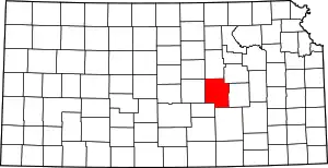 Map of Kansas highlighting Marion County | |
| Unincorporated communities | ||
| Ghost towns | ||
| Townships | ||
| Footnotes | †This community is designated a Census-Designated Place (CDP) by the United States Census Bureau. ‡This community also has portions in an adjacent county or counties. | |
This article is issued from Wikipedia. The text is licensed under Creative Commons - Attribution - Sharealike. Additional terms may apply for the media files.