Luena | |
|---|---|
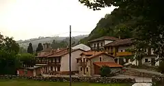 Entrambasmestas village, Luena. | |
_Mapa.svg.png.webp) Location of Luena | |
 Luena Location in Spain | |
| Coordinates: 43°5′45″N 3°54′1″W / 43.09583°N 3.90028°W | |
| Country | |
| Autonomous community | Cantabria |
| Province | Cantabria |
| Comarca | Pas and Miera valleys |
| Judicial district | Medio Cudeyo |
| Capital | San Miguel de Luena |
| Government | |
| • Alcalde | José Ángel Ruiz Gómez (2007) (PRC) |
| Area | |
| • Total | 90.54 km2 (34.96 sq mi) |
| Elevation | 457 m (1,499 ft) |
| Population (2018)[1] | |
| • Total | 601 |
| • Density | 6.6/km2 (17/sq mi) |
| Time zone | UTC+1 (CET) |
| • Summer (DST) | UTC+2 (CEST) |
Luena is a municipality located in the autonomous community of Cantabria, Spain. According to the 2007 census, the municipality has a population of 831 inhabitants. Its capital is San Miguel de Luena. The municipality consists of a valley which runs from the Cantabrian Mountains to the North, until it reaches the valley of the river Pas. It is a markedly rural area, where the traditional economic activity evolves around the cow.
Towns
- Bollacín
- Bustasur
- Carrascal de Cocejón
- Carrascal de San Miguel
- Cazpurrión
- El Cocejón
- Entrambasmestas
- La Garma
- Llano
- Los Pandos
- Pandoto
- La Parada
- Penilla
- La Puente
- Resconorio
- Retuerta
- San Andrés de Luena
- San Miguel de Luena (capital)
- Sel de la Carrera
- Sel de la Peña
- Sel del Hoyo
- Sel del Manzano
- Selviejo
- Tablado
- Urdiales
- Vega Escobosa
- La Ventona
- Vozpornoche
References
- ↑ Municipal Register of Spain 2018. National Statistics Institute.
External links
- Luena - Cantabria 102 Municipios
.JPG.webp)
House in Selviejo village, Luena.
.JPG.webp)
Livestock in the Luena Valley.
This article is issued from Wikipedia. The text is licensed under Creative Commons - Attribution - Sharealike. Additional terms may apply for the media files.