Magyarcsanád
Cenadul Unguresc, Чанад | |
|---|---|
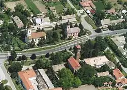 The main street of Magyarcsanád on an aerial photo | |
 Coat of arms | |
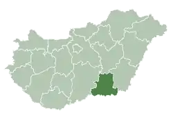
 Magyarcsanád Location of Magyarcsanád in Hungary | |
| Coordinates: 46°10′01″N 20°37′01″E / 46.167°N 20.617°E | |
| Country | Hungary |
| Region | Southern Great Plain |
| County | Csongrád |
| Subregion | Makói |
| Rank | Village |
| Area | |
| • Total | 48.19 km2 (18.61 sq mi) |
| Population (1 January 2008)[2] | |
| • Total | 1,538 |
| • Density | 32/km2 (83/sq mi) |
| Time zone | UTC+1 (CET) |
| • Summer (DST) | UTC+2 (CEST) |
| Postal code | 6932 |
| Area code | +36 62 |
| KSH code | 05962[1] |
| Website | www |
Magyarcsanád (Romanian: Cenadul Unguresc; Serbian: Чанад, romanized: Čanad) is a multi-ethnic village located in Csongrád-Csanád County, southeastern Hungary, near the Mureș (Maros) River. The Maros is a border-river here between southern Hungary and northern Romania.
The population is mainly Hungarian, but many Romanians, Serbs and Romani people also live here. Magyarcsanád has four churches: a Roman Catholic, a Calvinist, a Serbian Orthodox, and a Romanian Orthodox one.
The village has an own outskirt called Bökény directly near the Maros. Here is a tumulus (kunhalom) in which archeological artifacts were found.
Magyarcsanád has a partner-settlement, Comloșu Mare, in Timiș County, Romania.
An old stone cross was erected near Magyarcsanád in the Middle Ages. The cross still stands.
There is a small isle called 'Senki szigete' (English: No Man's Isle) some kilometers eastward from Magyarcsanád on the border river Maros. The isle is inhabited by Phalacrocoracidae (Phalacrocorax carbo).
References
- 1 2 Magyarcsanád at the Hungarian Central Statistical Office (Hungarian).
- ↑ Magyarcsanád at the Hungarian Central Statistical Office (Hungarian). 1 January 2008
External links
- Vendégváró (Hungarian)
- (Térképcentrum, Hungarian, with map)
- Gyalogló (Hungarian)
- Hungarian Central Statistical Office about Magyarcsanád (English)
- Csongrád County Government about Magyarcsanád (Hungarian)
- (satellite map, in the centre-right in Google Map)
| Cities with county rights |
|   |
|---|---|---|
| Towns | ||
| Large villages | ||
| Villages |
| |
| Other topics |
| |