Provincial Road 542 | ||||
|---|---|---|---|---|
| Route information | ||||
| Maintained by Manitoba Infrastructure and Transportation | ||||
| Length | 21 km[1] (13 mi) | |||
| Existed | 1984–present | |||
| Major junctions | ||||
| South end |  PR 257 in Kola PR 257 in Kola | |||
| North end |   PTH 1 (TCH) / PTH 41 near Kirkella PTH 1 (TCH) / PTH 41 near Kirkella | |||
| Location | ||||
| Country | Canada | |||
| Province | Manitoba | |||
| Highway system | ||||
| ||||


Provincial Road 542 (PR 542) is a road in southwestern Manitoba, Canada. At its southern end, it intersects with Manitoba Provincial Road 257 at Kola, Manitoba. It runs due north until the Trans-Canada Highway near Kirkella, where the road becomes Manitoba Highway 41.
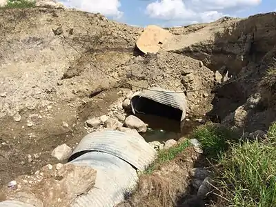
Manitoba Provincial Road 542 near Kirkella, Manitoba after being washed out by torrential rain in July, 2014.
External links
References
- ↑ Overview map of MB 280 (Map). Yahoo Maps. Retrieved 2008-04-17.
This article is issued from Wikipedia. The text is licensed under Creative Commons - Attribution - Sharealike. Additional terms may apply for the media files.