Mariental | |
|---|---|
 Coat of arms | |
Location of Mariental within Helmstedt district 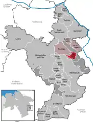 | |
 Mariental 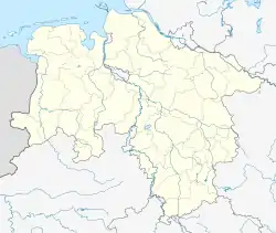 Mariental | |
| Coordinates: 52°17′N 10°59′E / 52.283°N 10.983°E | |
| Country | Germany |
| State | Lower Saxony |
| District | Helmstedt |
| Municipal assoc. | Grasleben |
| Subdivisions | 2 |
| Government | |
| • Mayor | Fred Worch (CDU) |
| Area | |
| • Total | 6.53 km2 (2.52 sq mi) |
| Elevation | 137 m (449 ft) |
| Population (2021-12-31)[1] | |
| • Total | 931 |
| • Density | 140/km2 (370/sq mi) |
| Time zone | UTC+01:00 (CET) |
| • Summer (DST) | UTC+02:00 (CEST) |
| Postal codes | 38368 |
| Dialling codes | 05356 |
| Vehicle registration | HE |
| Website | www.samtgemeinde-grasleben.de |
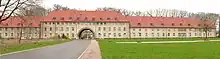
Mariental is a municipality in the district of Helmstedt, in Lower Saxony, Germany. The Municipality Mariental includes the villages of Mariental-Dorf and Mariental-Horst. See also Mariental Abbey.

The former abbey Mariental in Mariental-Dorf
The former military air base in Mariental-Horst
References
Towns and municipalities in Helmstedt (district) | ||
|---|---|---|
Coat of arms | ||
This article is issued from Wikipedia. The text is licensed under Creative Commons - Attribution - Sharealike. Additional terms may apply for the media files.