Marion Township | |
|---|---|
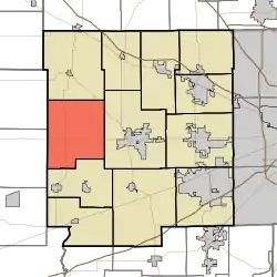 Location in Hendricks County | |
| Coordinates: 39°46′06″N 86°38′14″W / 39.76833°N 86.63722°W | |
| Country | United States |
| State | Indiana |
| County | Hendricks |
| Government | |
| • Type | Indiana township |
| Area | |
| • Total | 38.62 sq mi (100.03 km2) |
| • Land | 38.62 sq mi (100.03 km2) |
| • Water | 0 sq mi (0 km2) 0% |
| Elevation | 968 ft (295 m) |
| Population (2010) | |
| • Total | 1,402 |
| • Density | 36.3/sq mi (14/km2) |
| GNIS feature ID | 0453606 |
Marion Township is one of twelve townships in Hendricks County, Indiana, United States. As of the 2010 census, its population was 1,402.[1]
Geography
Marion Township covers an area of 38.62 square miles (100.0 km2), all land.
Unincorporated towns
(This list is based on USGS data and may include former settlements.)
Adjacent townships
- Eel River Township (north)
- Center Township (east)
- Clay Township (south)
- Floyd Township, Putnam County (west)
- Jackson Township, Putnam County (northwest)
Cemeteries
The township contains fifteen cemeteries: Abner-Ragan, Dickerson, Higgins, New Winchester Baptist, New Winchester, Noland Number 1, Peck, Robbins, Ryner, Sears, Shannon, Tinder, Turner, Turner Farm and Vannice.
Major highways
Airports and Landing strips
- Layne Field 5II1
References
- ↑ "U.S. Census website". Retrieved July 20, 2008.
External links
Municipalities and communities of Hendricks County, Indiana, United States | ||
|---|---|---|
| Towns | Map of Indiana highlighting Hendricks County | |
| Townships | ||
| CDPs | ||
| Other communities | ||
| Footnotes | ‡This populated place also has portions in an adjacent county or counties | |
This article is issued from Wikipedia. The text is licensed under Creative Commons - Attribution - Sharealike. Additional terms may apply for the media files.