Matkins is an unincorporated community in southwest Harrison County, in the U.S. state of Missouri.[1]
The community is at the junction of Missouri routes P and TT. The site is on a ridge between White Oak Creek to the west and Little Sampson Creek to the east.[2] The community is approximately eight miles southwest of Bethany.[3]
History
A post office called Matkins was established in 1880, and remained in operation until 1907.[4] The community bears the name of an early settler.[5]
References
- ↑ U.S. Geological Survey Geographic Names Information System: Matkins, Missouri
- ↑ Matkins, MO, 7.5 Minute Topographic Quadrangle, USGS, 1984
- ↑ Missouri Atlas & Gazetteer, DeLorme, 1998, First edition, p. 20 ISBN 0-89933-224-2
- ↑ "Post Offices". Jim Forte Postal History. Retrieved October 3, 2016.
- ↑ "Harrison County Place Names, 1928–1945 (archived)". The State Historical Society of Missouri. Archived from the original on June 24, 2016. Retrieved October 3, 2016.
{{cite web}}: CS1 maint: bot: original URL status unknown (link)
Municipalities and communities of Harrison County, Missouri, United States | ||
|---|---|---|
| Cities | 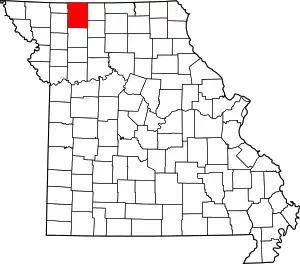 Map of Missouri highlighting Harrison County | |
| Villages | ||
| Townships | ||
| Unincorporated communities | ||
| Footnotes | ‡This populated place also has portions in an adjacent county or counties | |
40°10′55″N 94°09′49″W / 40.18194°N 94.16361°W
This article is issued from Wikipedia. The text is licensed under Creative Commons - Attribution - Sharealike. Additional terms may apply for the media files.