Meliki
Μελίκη | |
|---|---|
 Meliki Location within the regional unit 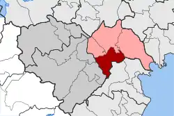 | |
| Coordinates: 40°31′N 22°24′E / 40.517°N 22.400°E | |
| Country | Greece |
| Administrative region | Central Macedonia |
| Regional unit | Imathia |
| Municipality | Alexandreia |
| • Municipal unit | 99.0 km2 (38.2 sq mi) |
| Population (2011)[1] | |
| • Municipal unit | 7,104 |
| • Municipal unit density | 72/km2 (190/sq mi) |
| Community | |
| • Population | 3,116 (2011) |
| Time zone | UTC+2 (EET) |
| • Summer (DST) | UTC+3 (EEST) |
| Vehicle registration | ΗΜ |
Meliki (Greek: Μελίκη) is a village and a former municipality in Imathia, Greece. Since the 2011 local government reform it is part of the municipality Alexandreia, of which it is a municipal unit.[2] The municipal unit has an area of 98.962 km2.[3] Population 7,104 (2011). Meliki is near Vergina, the place where the tomb of Philip II of Macedon was discovered.
External links
References
- 1 2 "Απογραφή Πληθυσμού - Κατοικιών 2011. ΜΟΝΙΜΟΣ Πληθυσμός" (in Greek). Hellenic Statistical Authority.
- ↑ "ΦΕΚ A 87/2010, Kallikratis reform law text" (in Greek). Government Gazette.
- ↑ "Population & housing census 2001 (incl. area and average elevation)" (PDF) (in Greek). National Statistical Service of Greece. Archived from the original (PDF) on 2015-09-21.
This article is issued from Wikipedia. The text is licensed under Creative Commons - Attribution - Sharealike. Additional terms may apply for the media files.