| Merewether Heights Newcastle, New South Wales | |||||||||||||||
|---|---|---|---|---|---|---|---|---|---|---|---|---|---|---|---|
 Merewether Heights | |||||||||||||||
| Coordinates | 32°56′56″S 151°44′06″E / 32.949°S 151.735°E | ||||||||||||||
| Population | 1,400 (2016 census)[1] | ||||||||||||||
| • Density | 2,330/km2 (6,000/sq mi) | ||||||||||||||
| Postcode(s) | 2291 | ||||||||||||||
| Area | 0.6 km2 (0.2 sq mi) | ||||||||||||||
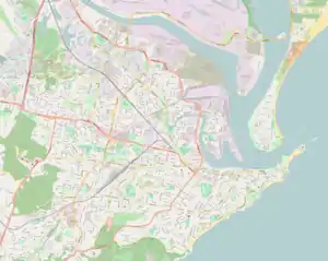
| Location |
| ||||||||||||||
| LGA(s) | City of Newcastle | ||||||||||||||
| Parish | Newcastle | ||||||||||||||
| State electorate(s) | Newcastle | ||||||||||||||
| Federal division(s) | Newcastle | ||||||||||||||
| |||||||||||||||
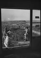
View of Merewether Heights in 1953
Merewether Heights is a suburb of Newcastle, New South Wales, Australia, located 6 kilometres (4 mi) southwest of Newcastle's central business district near the Glenrock State Recreation Area. It is part of the City of Newcastle local government area.
References
- ↑ Australian Bureau of Statistics (27 June 2017). "Merewether Heights (State Suburb)". 2016 Census QuickStats. Retrieved 9 February 2018.
- "Merewether Heights". Land and Property Management Authority - Spatial Information eXchange. New South Wales Land and Property Information. Retrieved 14 May 2008.
This article is issued from Wikipedia. The text is licensed under Creative Commons - Attribution - Sharealike. Additional terms may apply for the media files.